
Replies sorted oldest to newest

I've always been partial to the Interchange/ locals yard in west chicago, IL.  This UP yard (former CNW) connects up with the EJ&E (might be CN now).   The 3 main lines of the UP cross the EJ&E and there's quite a bit of trackage that allows trains to move not only from one yard to the other but directly to the main lines of either railway.   There's also an Auto rack facility and a bunch of other goodies.    Actually if you go way back to the 1920-30's West Chicago is even more interesting as it had a Chicago Aurora and Elgin (interurban rail) track running right down the center of main street. 

https://www.google.com/maps/@4...,4192m/data=!3m1!1e3


Attachments

Images (1)
  • mceclip0
Last edited by modelrailroadbenchwork

Google Maps/Earth is a great tool (especially street view) for research and inspiration for model railroad vignettes. This is especially true for industrial areas and street running. You'll also find that there's a prototype for a lot of things you would do with a model railroad that you don't think would exist in prototype. One of my favorites is the return loop at the East end of the UP (SP) Colton Yard in San Bernardino County.

The "balloon track" and wye go back to the SP days. The bypass track at the top (arches past the balloon track on the North side) is newer. The wye connects to the mainline track (bottom) via the crossover at the West side and joins at the East right before the old "Colton Diamond" which has since been replaced by a fly-over. There were also cutoffs that led to the North-South tracks shared by Santa Fe headed to the San Bernardino Depot and Riverside (UP shared the tracks prior to the SP merger and SP used them for Interchanging). If I had the space, I was thinking this would be interesting to Model. I think I even have an RR-Track file rendering of the original configuration somewhere.

By the way, at the West end of the yard there's a still-operational hump with a nice arrangement of retarders. Oh, to have the space.

Colton Wye AerialColton Wye Map

Attachments

Images (2)
  • Colton Wye Aerial
  • Colton Wye Map
Last edited by AGHRMatt

I hope I'm not too late, but I wrote something similar to this a year ago for an N scale forum as a layout idea. It might be harder to do with the space constraints in O, but here it is, copied/pasted from my original N scale post:

A transloading facility, such as the one operated by the TTI Railroad in Maysville,KY is used to move carloads of bulk materials like coal or rock. Wikipedia goes into greater detail on transloading with a brief article on the subject: [url]https://en.wikipedia.org/wiki/Transloading[/url]

The TTI facility in Maysville is a fairly simple operation. Four yard tracks stem from the main line, another spur runs beneath the simple steel fabricated building where materials are unloaded via conveyor onto barges sitting in the Ohio River. From a satellite image we can easily see the small "yard" west of the facility, and the facility itself.


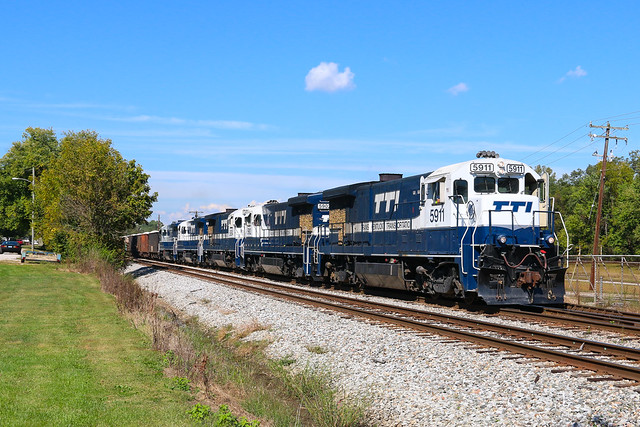
Train operations here are basic. An eastbound TTI train, after coming off home rails onto CSX in Maysville and running the power around the train, will pull past the switch off the main line. Once the conductor throws the switch, the train backs down into the small yard. TTI can run 100 car coal trains or rock trains to the facility. The previous day's train was a 65 car rock train.

After dropping off a cut of cars at the first yard track (the one farthest to the left), the train will pull forward a short distance so the conductor can line the switch to the second yard track. The train will once again back into the spur until it is full of cars. This process is repeated until the entire train is parked in the yard. Empties are also parked in the yard for pickup by trains. TTI will usually take empties back home to Paris, but in yesterday's case, the engines ran light and the empties were left behind for another day.

The TTI facility is a metal structure with the center used for unloading cars. A track extends further east of the building so a locomotive can move cars through the building for unloading. A locomotive that stays at the facility pulls cars through the building to unload them. It takes about thirty minutes to unload two cars.


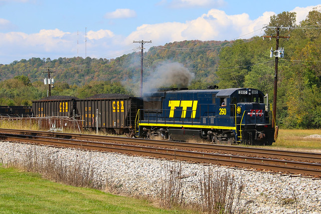
The prototype facility has plenty of signage with large lettering, which makes for easy sign-making if you're modeling! A sign about wearing safety paraphernalia was to the west side of the road crossing in addition to the TTI / CSX sign. The smoke stack on the right of the second photo belongs to a power plant further downriver, and is unrelated to this transload operation. Fencing closes off the area from its surrounding neighbors and a fence sits between the CSX main the the facility itself. A small house-like building by the CSX main (right of the tree at the crossing) serves as an office for the operation.


I thought about doing more but there wasn't much response to this post so I haven't done any others. I railfan frequently so I see all kinds of stuff out there.

Last edited by SimRacin40

For those whose interests lie in the past, there is historicaeriels.com

http://www.historicaerials.com/aerials.php?op=home

They have a great collection of both historic aerial photographs as well as historic topographical maps.  I've been using this for years, and my most current project is using the tool to research aluminum reduction facilities in Washington state (particularly Kaiser's Mead works), as well as the Kiaser rolling mill east of Spokane, and the Reynolds Aluminum facility in McCook, IL. 

A sample for those who would like to see what the old ALCo plant looked like in Schenectady, NY, type in:

Erie Blvd. and Nott St., Schenectady, NY

And you will be at the corner of the old headquarters building.  You can see aerial photos from 1952 to 2013, as well as topographic maps from 1893 to 1981. 

Regards,

Jerry


modelrailroadbenchwork posted:

I've always been partial to the Interchange/ locals yard in west chicago, IL.  This UP yard (former CNW) connects up with the EJ&E (might be CN now).   The 3 main lines of the UP cross the EJ&E and there's quite a bit of trackage that allows trains to move not only from one yard to the other but directly to the main lines of either railway.   There's also an Auto rack facility and a bunch of other goodies.    Actually if you go way back to the 1920-30's West Chicago is even more interesting as it had a Chicago Aurora and Elgin (interurban rail) track running right down the center of main street. 

https://www.google.com/maps/@4...,4192m/data=!3m1!1e3


I love Google maps and Earth. I recognized West Chicago right away because I've been there to train watch a few times. The spot to sit is in the lower right where the single track CN crosses the triple track UP. There's a little parking lot and a tower. Very busy!

IMG_7182IMG_9121IMG_9372

I also used Google for my own layout research, not just for the track work, but also for the structures. It is great for modeling modern. The following are all on my layout.

Pigs Eye Yard

Hiawatha Milling District

Unfortunately, the Ford plant has been torn down, but the street view is able to turn back the clock to when it was still alive.

Ford Plant

Street view

Attachments

Images (3)
  • IMG_7182
  • IMG_9121
  • IMG_9372
Last edited by Big_Boy_4005

Good thought for the topic, Garrett. The thought came to me after reading John Armstrong and trying to find elements of a railroad to include in a layout design. Some have posted links to the insurance documents, historical groups have made documents and maps available digitally. Elliot's dream/nightmare inspired me after observing his hand drawn design and then finding photos of the prototypes and satellite views of existing facilities.

Now, some of these have become standard design elements that I use based on Givens and Druthers of individuals.

Turning a train around on the fly, or reverse loops, can hose up a clean layout design. The "balloon" shape (as noted by Matt) has become a favorite of mine and has and still is used by many railroads. The Humboldt balloon is a favorite. It had port service, too. Other facilities, activities and scenic items can be designed into the inside of the shape as it was used prototypically. The ARR has one at the main facility in Anchorage.

Here is a new one I discovered while researching the Route of the Empire Builder. Oil fracking and oil transportation have taken over rail traffic in North Dakota. While designing an around the walls layout and not wanting too large of a peninsula intruding on the center people space, using this shape worked well. It's an oil loading facility in Trenton, ND. Adding another set of switches on the opposite side provides a way to reverse a train in either direction. The space itself can be whatever you want it to be giving the train a reason to be or something to do. ACE worked this into a corner of a small layout design after DoubleDaz shared it.

ND oil train loading trenton


Attachments

Images (4)
  • balloon1952
  • Eureka1870
  • ARR Anchorage Balloon
  • ND oil train loading trenton

Add Reply

Post
The Track Planning and Layout Design Forum is sponsored by

AN OGR FORUM CHARTER SPONSOR

OGR Publishing, Inc., 1310 Eastside Centre Ct, Suite 6, Mountain Home, AR 72653
800-980-OGRR (6477)
www.ogaugerr.com

×
×
×
×
Link copied to your clipboard.
×
×