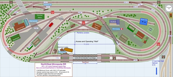
Thinking about how to improve this layout, I thought about increasing the layout length from 17' to 18', wondering to what purpose that extra foot could be put. I decided to revise all the turnouts to O-72 for smoother running and to extend the reach of O-72 locomotives, and to add easements and broaden curves when possible. The layout minimum diameter is still 48", no getting around that without increasing the layout width. There remains only two curved sections of O-48 highlighted in red, the rest of the layout is O-60, O-72, or wider (a section of O-96).
- O-72 locomotives can now reach the station at Winnipeg in the middle-right, and can switch the nearby spurs.
- O-54 locomotives can do a bit more and can more navigate the O-60 return loop under Glenwood. And can also run the grade to Glenwood and switch the industries there, but cannot run the return loop.
A short 10" spur was added at Moorhead.
I have reset the era and local, from the fictional Minnesota area of the original plan, to locations and real place-names in North-west Minnesota: The NorthWest Minnesota layout plan features two railroads in one in a transition-period setting. The plan has the Great Northern RR (BNSF) around the outer mainline loop with sidings and a yard which are entirely O-72 and can accommodate large locomotives and equipment. The interior Soo Line (CP) mainline connects a level loop and junction hosting two return-loops, with a long grade to an elevated town return-loop with O-48 minimum diameter. Set in Northwest Minnesota, the plan models that Soo Line from Glenwood Minnesota and connection to Minneapolis, running north through lake country across hills and prairies to meet the Canadian Pacific at Winnipeg, Manitoba. Along the way, the Soo Line junctions with the Great Northern RR at Erskine Junction running East to West across the northern tier of the country. Back in the late 1800s through 1912, the area featured navigable rivers by steamboat, moving passengers and freight often towing barges, from Moorhead, Minnesota to Winnipeg during months between the spring ice thaw and winter freeze. “Empire Builder” James J. Hill even ran a steamboat line on the Red for a few years, until his rail connections provided a faster and less expensive route, but in this layout plan, the steamboat operation is brought forward in time a few decades with the dock at Moorhead and optional steamboat mooring at Winnipeg, offering excursions and dinner-cruises. You can read more about steamboats on the Red River here.
My Norwegian and Swedish ancestors were "sod-busters" farming in Southeast North Dakota in the late 1800s, and some even living in sod-houses in their first years establishing a homestead. I grew up in Fargo across the Red River from Moorhead depicted in the plan. During the winters, as a young guy I used to cross-country ski on the frozen Red during the brutal winters.


