Updated 11/28/2019:
Happy Thanksgiving everyone! I certainly have much to be grateful for.
Thinking aloud: I have been contemplating how to treat the hillside to the north (slopes toward the backdrop) of the Panhandle mainline just after it comes across the bridge to Steubenville (west bound).
In the real world, as shown in the photo below (taken from McKim’s Ridge across the Ohio River), the land slopes upward and away from the river.
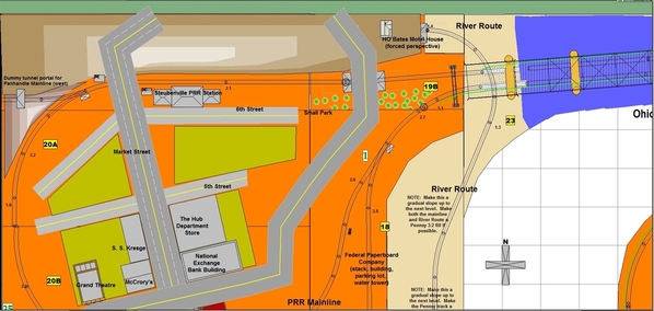
Here's the layout section in question.
I am referring to the top (northern-most) track to the left of the “19B” as it runs past (westbound) past the Steubenville PRR station. Unfortunately, the layout is only 11’ deep from front to back here and the section north of the track is only about 20” deep. Therefore, I must selectively compress and represent the hillside in only 18-20” of depth. Fortunately, I think that is enough, especially if I pursue the alternative I am considering.
Initially, I thought about just starting at table top level and making the terrain slope upwards till it meets the backdrop. Recently though, I have had reason to re-evaluate the plan. The alternative is to create a stone wall 8 scale feet (2”) high that will run west from the 4th Street overpass (to the left of the “19B”) to the vicinity of the Gould No. 5 tunnel portal in the northwest corner of the layout. Near the portal (to the left of Market Street), the wall will expand into a wing wall. To my mind, that has the following advantages:
- The bottom of the wall (maybe most of the wall) will not be generally visible to anyone standing at the far (southern) edge of the layout. In fact, it is likely that visitors will only be able to see the backs of buildings that face North 4th Street and the street side of the PRR station. However, anyone standing in the aisle facing the bridge will only have to turn their heads 90 degrees to see down 6th Street and the Pennsy mainline.
- Starting the slope 2” (8 scale feet) above the tabletop allows the hill to be much higher overall. At its northwest corner (~40” from the western wall and ~20” from the northern wall), the track begins its O72 curve toward the southern edge of the layout. In order to accommodate the Gould No. 5 tunnel portal and the dummy leg of a wye depicting the westward track of the Panhandle, the hillside should reach a height of at least 24” at the backdrop. That way, the portal will not look out of place.
- The wall will add some interest to the scene. It can be decorated with vines and drain pipes emptying into the ditch along the north side of the track.
More when I know it. 
George


