Updated 12/17/2018:
Over the past few days I have re-thought my plan of attack for installing the bridge. Specifically, I have decided to construct the C&P River Route tunnel portal and surrounding scenery below the western end of the bridge, as well as the terrain on the WV side BEFORE putting the bridge in place permanently. These areas will be difficult to reach and work with if the bridge is there.
Photos of the western area:
Photos of the eastern area:
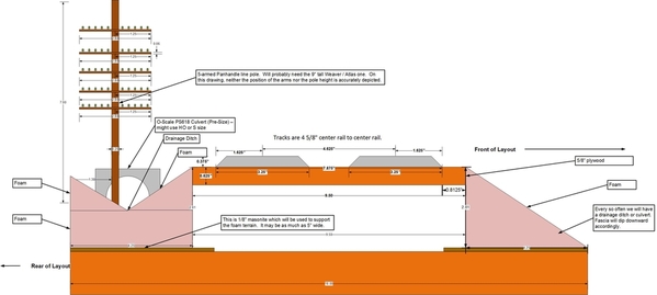
I want the area east of the stone arch to have a cross-section that looks like this:
All of the above means that while we have the bridge and piers in place temporarily, we must mark those locations, remove the bridge, delineate the river boundaries, perform the western portal and track work, do the eastern landscaping (rough), and then put the bridge in place permanently. That's the rough order of things, near as I can figure it. I'm sure there will be some adjustments.
I was originally going to plant some cat-tails along the banks of the river, but it is moving water (pretty good clip 2-4 mph?). Cat-tails do not thrive in moving water. Looking at some photos of the riverbank, it seems that trees grow right up to the bank and overhang it, so that's what we're going to do as well. There will be a dead tree near the base of Pier 1 (the shorty) as well as some junk.
More when I know it. 
George


