 This is a great pic The Third ave and Second Ave El's met here That is a Forney steam engine pulling the coaches
Third ave El


Interior of a Blue Bird

Brooklyn El construction

Connecting the culver


|
|
This is a great pic The Third ave and Second Ave El's met here That is a Forney steam engine pulling the coaches
Third ave El
Interior of a Blue Bird
Brooklyn El construction
Connecting the culver


Replies sorted oldest to newest
Great pics!
Peter
not to mention rush hour at Coney Island...


Ben
You really come up with some great photos.
The first one is at Chatham Square before the rebuild with the flyover for the South Ferry branch. When this photo was taken, third ave trains going to and from South Ferry crossed on grade
The second Photo is at the W 23rd street Ferry Terminal. That is a NY Railways Green Line car running on the 23rd st Crosstown line. This car had the distinction of stopping in front of Madison Hardware. Service ended in 1936 when parent, 5th ave coach substituted buses for the service.
The third photo is during the great 1947 snowstorm, december 26th i think/
The Blue birds were a real modern car way ahead of their time. In the 1930's They worked on the Fulton Street line in Broolyn before the A train was built.
Not sure about the Brooklyn El photo. It almost looks like downtown Brooklyn near Sands Street.
Larry
The caption on that Brooklyn shot said 4th Ave I didn't think there was an el on 4th I know it went down 5th to 36th and then down to Third
Ben
I was thinking that the large buildings in the background were downtown brooklyn but i suppose it could look like that from about 36th street looking towards downtown. From the photos i have seen of the station and trackage at the location where the 5th ave and culver line trains split at 36th street, it could have been a substantial structure like in the picture that could have stretched between 5th and 4th ave. West end trains operated through here before being connected to the 4th ave subway. Also i guess the 36-39th street yard was located in this area as well. Think it was constructed about this time
Here is the Fifth ave El at 36 st. Culver coming in from the left.


Thank you Ben!!!!
Ben...those are really great pics!! If I had to do it over again, I would have much more elevated on the layout. I tried to model the older looking structure like in some of the pictures above....boy are those neat photos Ben...
Thanks,
Alan
Ben
That photo is a puzzler. I looked at it again. Two things to consider in locating the photo. It appears to be construction associated with the Dual contracts and the structure looks like its at a pont where there is a station but not with a center platform. I would say its about 1915 or so in time, about 20 years earlier than the photos you posted later. The second point is that this construction was not in a street but on private right of way and there is no existing rail line in the street that one can see. The buildings in the backround suggest it is near downtown. The Culver line in the vicinity of 36th street ran on private right of way over towards Ditmas Avenue. If its marked 4th avenue, the location doesn't seem right. Did the 3rd ave extension of the 5th ave el have any non center platforms?
Larry
I really think the caption is wrong on that The construction looks nothing like the 5th ave El or anything else around it. I have a feeling it may be Myrtle Ave
Can you guess where this is
![]()
![]()


Hi Ben
The new picture is South Ferry The 2nd and 3rd avenue trains are on the left while the 6th and 9th ave trains would be on the right. There was a connection between the two systems and you can see that in the foreground. Looks to me it was taken about the point in time when these lines were being electrified.Interesting to see telephone pole in Manhattan!
As for the earlier photo, the only place the Myrtle ran on Private Right of way was North of Wycoff avenue and it was two track in there with center platforms I believe. This photo shows an el structure with 3 trackways but local platforms.
Only private right of way I know of was the original Culver line from Mcdonald ave to 9th ave Later became the Culver shuttle after IND connection. It did have outside stations

Ben
I was thinking the same thing. Maybe it was 14th ave. Was there a station at that point on the Colver line?
Can you guess where this is
![]()
![]()
Hobroken, looking east, toward New York Bay?
Richie
Richard
its South Ferry in Manhattan about the turn of the century.
Bob
Wallabout would be a pretty cool modeling subject The Lackawanna, Erie, Pennsy, NYC, Lehigh Valley, CNJ , NYO&W, BEDT and B&O all had a presence there. The Lackawanna owned its pier and yard but the others shared it ala a union terminal. The Federal government claimed it in 1940 to expand the Navy Yard. That 4001 loco looks pretty weird with that giant pantograph on top of a little engine.

I like this Ny scene too

Hi, Ben.
First, let me thank you for starting such an awesome thread. Our region is so rich in railroading history. I can lose myself for hours researching it. Thanks again.
That last picture you posted intrigues me. Might that be 207th Street?
Bob
Yes that's the 207 st yard They used to have their own car floats So much railroad history here and so little railroads left

Here is a photo of BEDT 15 down at Wallabout Market. That is the Erie terminal in the backround. Interesting street running in Brooklyn. BEDT locomotives would be floated over from North 6th street engine terminal on the first float of the day. At the end of the day, they would return to North 6th street on the last float of the day. The Pidgeon Strret yard in Long Island city also worked this way.


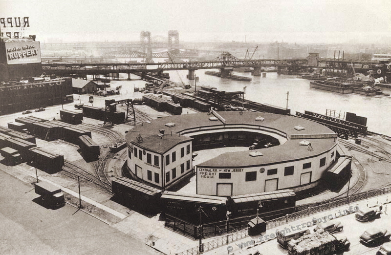
Here's one of my favorites, the Jersey Central freight terminal in the South Bronx.
Here's a link to a great site about it.
http://members.trainweb.com/be...ndloco/crrnjbxt.html
Peter
I love this thread!!! Keep it going guys!! Sure wish I lived near you all....
Alan
This is 11th Ave in Manhattan Little crowded for street running

The guy on the horse was a rule to lead the train. Most of them were Italian imigrants and wer known as West Side cowboys


OK I got it from a very reliable source Joe Frank posted these for me. it is looking SE (in direction towards Prospect Park further SE) along 10th Street from between 3rd Avenue towards 4th Avenue and the building of the sub-steelwork of the new IND 4th Avenue Station (later encased in concrete and brick) of the IND huge viaduct portion over the Gowanus Canal. View is about 1929-30.


Hey Guys...these photos are out of this world. I visit these places all the time. as i live in Queens, New York. plus a big visitor to the HellGate bridge . what a view from up there. A great bridge indeed. have been going up there since 1983. Keep up the great work.

Thanks for sharing these great city shots!
Ben
Mystery solved. If you look into he distance on the earlier photo , you can also make out the bridge at 4th ave. The walkway in the center in the newer photo is interesting.
Hi, Anthony.
For you, a photo of the bridge under construction and an aerial view looking north toward the Bronx:


Bob
Some fascinating stuff! Thanks for posting!
This one is pretty Good The original Grand Central Terminal


Not exactly "vintage" material but since we had a few **** Gate Bridge posts, I thought this impressive night view of CP's Holiday Train on the bridge was worthy of inclusion:

Bob
What year did this happen?
I've seen photos of CP's train, but never so much as a suggestion that it ever got near the Northeast, much less actually within NYC's boundaries.
---PCJ
The CP Holiday train would be on its way into Queens. Pewrhaps it was going to the Fresh Pond Interchange with the New York An Atlantic and the LIRR.
My old NY -
http://steves3roscale.shutterfly.com/pictures/5177
1961 dongan hills, knickerbocker class steam ferry.

1970 Billboard / Batwing bus - St. George Ferry city bus terminal.

One of eight S2 diesels sent off Island, mid 70's due to the MTA take over.

St. George Yard. now replaced by a baseball stadium and park.

Old SIRT cars, long gone.


Hey Steve Did you recognize Staten Island in one of my pics
Ben
Your second photo looks like Hanover square in lower manhattan on the 2nd and 3rd ave els line going to South Ferry. There is a gas lamp on the street under the el .
These are Brass LUV cars I run at my club


Love that twin stack ferry, Dongan Hills. Built 1929 and served until 1965. I rememeber riding on her across the bay.


Can you guess where this is
![]()
![]()
Hobroken, looking east, toward New York Bay?
Richie
Hey Steve Did you recognize Staten Island in one of my pics
Yes Ben, I have a few photos of that trade zone area. There were 2 gated sidings between the T-VILLE pool and the tunnel. Always a box car or two parked back there.
If you could get in there, I think a few sections of the rails can still be seen today.
I noticed them on the Google earth satellite a few years ago.
Great photos!
A little more Bronx:
The old Mott Haven coach yard south of 161st St, the last two photos with my old alma mater, Cardinal Hayes HS, in the background. ![]()


Jim
Here are some pretty good ones of the Brooklyn Army terminal


")
")

")
")
this is a great thread
thanks
Wallabout terminal with Thomas the tank train


Hey Steve Did you recognize Staten Island in one of my pics
Yes Ben, I have a few photos of that trade zone area. There were 2 gated sidings between the T-VILLE pool and the tunnel. Always a box car or two parked back there.
If you could get in there, I think a few sections of the rails can still be seen today.
I noticed them on the Google earth satellite a few years ago.
Steve
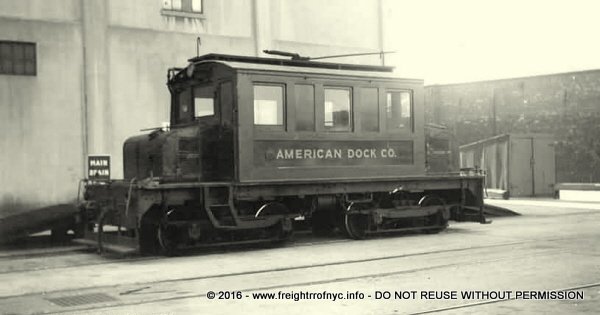
There is a great site that has a lot of info on this It was called American Dock Here is the site
http://members.trainweb.com/bedt/indloco/adc.html
Bob
The Highbridge photo is interesting as non of the work associated with the electrification of the Hudson line has begun at this time.
The BMT formerly BRT had an extensive system and transit complex in Downtown Brooklyn and Manhattan and over the Brooklyn Bridge. All of the BRT els in Brooklyn came into this area and trains from the various lines operated into Manhattan at various times during the period this operation was in existence. The service was during the period 1908 through 1944. In 1940, a substantial portion of the Brooklyn Elevateds were closed. Fukton Strret line trains continued to make the run from the Lefferts blvd station in the east , through Broadway junction onto the Broadway Elevated then onto the Lexingtin ave Elevated , then onto the Myrtle Ave Elevated into Sands street and over the Brooklyn Bridge. The IND A Train did not reach as far east as it does today. The last train to make the trip was a Myrtle Ave train . The Myrtle ave El truncated at this time to Jay street, continued to operate until 1969 with the Q cars being used.
At Sands Street in Brooklyn, their was a two level complex which served through service to Manhattan on one level and a loop for trains not serving Manhattan on the other level and tracks for trains terminating at Sands Street. Each level had multiple tracks and platforms.Sands Street Terminal had four tracks and four island platforms and a wall platform on the East. This was on the lower level to the West fo the Loop tracks and platforms Sands Street Loop had platforms on High Street(one island and two wall with two tracks) and on Sands Street (also two tracvks and one island and two wall platforms) . This too was on the lower level Sands Street to Manhattan had four tracks and two wall platforms plus two elevated street car platforms to the side of the outermost islands. This was on the upper level.
On the Manhattan side there initially was a station with two tracks and three platforms in a large railroad style train shed. This was expanded to include two separate platform areas and additional tracks. The BRT's Williamsburg bridge line also came into this area but was a subway installation with the Chambers Street Station adjacent to this area but below ground. LIRR trains also used the Chambers street terminal.
There were two tracks for El Trains on the Bridge in the center of the span. On Either side of the El Tracks was a track for streetcars which aslo ran from Brooklyn into Manhattan. The Trolley service lasted into 1950. PCC cars were the last to operate on this line. Here are photos of Sand Street and Brooklyn Bridge Stations.


Great pic of Sand St Larry
Bob,
Great Highbridge photo.
In the early fifties my father and I would visit that area to watch the construction of the Major Deegan Expressway. Too bad that the highway construction destroyed much of the railroad infrastructure in the area.
The most fascinating thing about the tracks of the Putnam Division was the lack of electrification. It was the only place in the Bronx where we could explore the area along tracks. Everywhere else had that third rail that made the area off limits to kids with any common sense!
It was also the only place where there was any steam in our part of the Bronx, although memories are vague since I was only 5 years old when diesels took over in the very early fifties. ![]()
Jim
Thanks for the greayt photo Bob. Just across the bridge we see in the photo was the terminal station for the Putnam division trains on the New York Central. There really were a number of transit choices for New Yorkers during these days.
Here is a photo of the station, 9th ave line in the forefront with the NYC station just behind.

just amazing stuff here...
Do you think this was the model for Lionels dual dump car?

This drill motor is still around Its sitting in Coney Island Yard shop.

The original money train Not fancy enough for Wesley Snipes

I wonder why they named it Pidgeon Street
Ben That one is easy. It was called Pidgeon street Yard because that was the name of the street on which it was located . The yard opened in 1906 and was in operation until 1976 operated by the BEDT. Freight cars were received at the Kent avenue yard and sorted and reloaded on a BEDT carfloat and brought to and from Pidgeon street by the BEDT.Capacity was about 100 cars and there were quite a few customers served.
Customers served at Pidgeon street included National Sugar better known as "Jack Frost" and the Daily News. There was never any direct connection between the LIRR and BEDT although it was discussed initially when the BEDT bought the property Pidgeon street was eventually renamed 55th avenue when Queens went to numbered streets and avenues. It is no longer a mapped street today.
In your photo, No 13 is switching the yard. 13 and 14 were identical locomotives. The Bridge in the backround is interesting . It is a double Bascule . It connected Manhattan Avenue in Brooklyn with Vernon Boulevard in Long Island City. The No 61 Crosstown and No 62 Graham ave trolleys used to cross it. I remember seeing it in service , opening and closing quite frequently as there was a lot of traffic on the Newtown Creek. The attached photo show the Bridge open.


Jim:
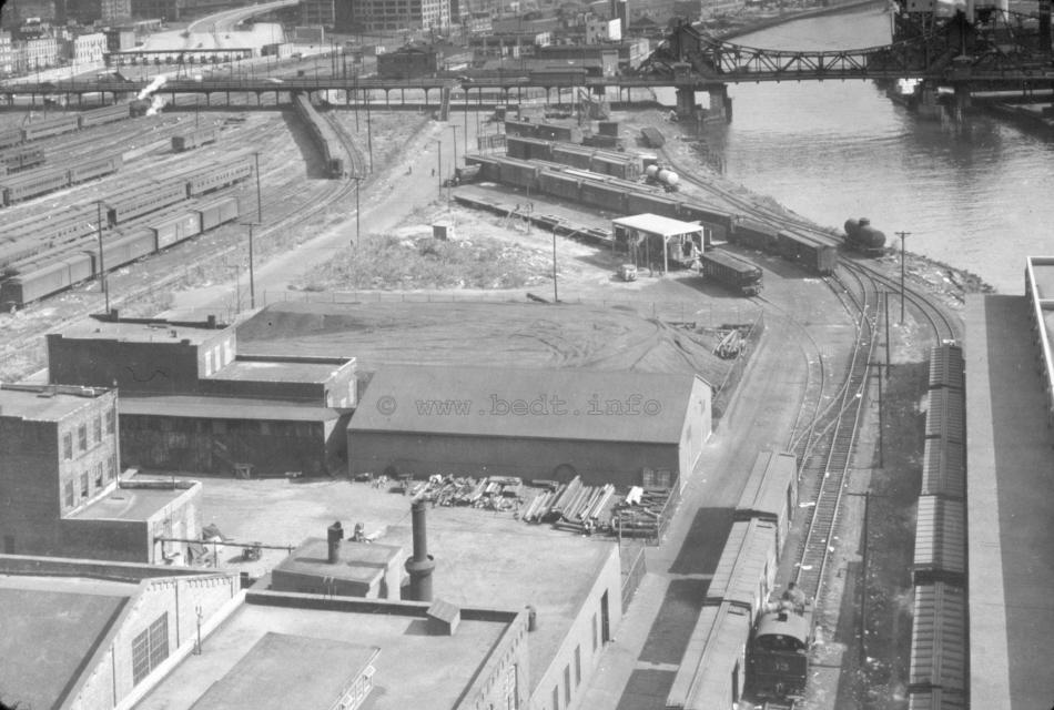
That was the CNJ car float which ran between Jersey City and the railroad's off line terminal in the Bronx. The locomotive is the 1001, purchased second hand to replace AGEIR boxcab 1000. By this point in time, due to the increasing problems in the neighborhood, the railroad found it prudent to remove the locomotive to the relative safety of Jersey City when the day's work was done.
Bob
Wow, I didn't know they were moved that far upriver. I always thought they were designed for lateral W-E and back. Thanks for the info.
Bob
Bob
Your map also shows a PRR Frt station i believe at 125th street in Manhattan. This was likely served by floats with the island platform. Just west of the NYC line crossing the Harlem River, there is a Barge Canal terminal shown. I wonder what that was like?
I did some additional research on that Pennsy facility at E. 125th Street. During the early 40s, the railroad offered both LCL and CL services here. Also, during the same period, Lehigh Valley hosted a similar operation at E. 124th Street. Evidently, both facilities were physically gone by the late 50s. I've been unable to locate a photograph of either operation.
One of the truly fascinating aspects of waterfront railroading was the ability to conduct operations without the physical presence of tracks on land. Shove the railroad owned vessel - carfloat, barge or lighter - to pier or ship side and away you go.
Here's a great color photo of the B&O's facility at West 12th Street with a substantial number of cars on floats taken in 1972. It was taken by Mr. Tom Flagg, the gentleman who authored the outstanding Morning Sun books about New York Harbor railroads.

Bob
Bob
I agree the Books by Tom Flagg are great . You need to see these to see what Nautical railroading was like in its era. The B&O photo is interesting. The three floats we see here had the center platform. Notice the rolling doors on the building that they face. The platforms lined up with these doors so that cars could be unloaded to the platforms and then into the warehouse structure at the pier line. These type of facilities were considered by the railrroads as freight stations . Most of the rail-lines serving New York City had such facilities on both the Hudson and the East rivers to deliver freight for truck pickup at these stations. I believe once empty, cars might be reloaded with freight that was left for outgoing shipments and the float then returning to the railroad's yard for forwarding on the railroad.
Believe the large building in this view was 30 church street. The Hudson Tubes original downtown terminal was below this building. In the 1960's, the World Trade Center rose upon this site.
As part of the Dual Contracts, The city brought rapid transit to the borough of Queens when it provided for the IRT and what became the BMT to operated joint service to Flushing and Astoria. As part of the expansion, the largest El Station on the system was constructed at Queensborough Plaza at the foot of the Queensborough Bridge. It was on two levels , had 4 island platforms and 8 tracks. The West 4th Street station on the IND subway replicated this arrangement below ground but the Queensborough Plaza Station had more lines serving it.
IRT lines coming from Manhattan included the Steinway line which is today's # & route and the 2nd El which was discontinued in 1942. The BMT 60th st Tunnel provided Manhattan BMT service. Going out to Queens were the Flushing Elevated and the Astoria Elevated.
On the IRT side , both Steinway trains and the 2nd Ave El had through trains to both Flushing and Astoria, Steinway trains using lov's and 2nd ave trains operating MUDC's or composites . The BMT side from Manhattan terminated at this station. The service used the BMT Standards, the Triplex cars and R-1-9's in the 1940's . Going out to Queens, BMT Q cars and earlier, Gate cars operated from the plaza to both Astoria and Flushing. The Q cars when rebuilt were painted in the Blue and orange city colors in 1939 and handled the special Worlds Fair service for the BMT while the IRT had a fleet of 50 cars it bought for the Worlds fair service which were known as ...well you guessed it.. Worlds Fair cars.
The elaborate service arrangement lasted until 1949 when the dual operations were eliminated and the Flushing service became all IRT and the Astoria service became all BMT. Astoria line was shorter and its platforms had to be cut down to handle the wider BMT cars. I suspect this is how the BMT got the Astoria Line because there was less work and cost associated with the platform modifications.
Here are afew photos.
The station at the Plaza, the IRT Steinway line is in service but the BMT line is still under construction.

A Flushing Line train coming from Manhattan. You can still see the second ave el track.

BMT Standards arriving from Manhattan on the now gone North side of the station. Astoria Train is behind it. The IRT 2nd ave El track is still in place in this view and was probably the last part of the 2nd ave line existing.

At the East End of the North Side of the station, a R-1-9 set is heading to the layup track to turn around for the trip back to Manhattan.

Again on the North Side now beyond the station, we see a group of BMT Q cars handling trains to and From Astoria and to Flushing. Thats a Steinway Transit car in the street. The Bridge line was the last Streetcar line in New York City closing in 1957.

On the Flushing Line heading EAST . the trackwork is now much less complicated. The crossover is still there and represents the only link for the No 7 line with the rest of the NY subway System. The Flushing line heads over Sunnyside yards at this point and in those days, one had quite a panoramma of the PRR long distance trains GG1s and the LIRR Freight yards.

Ben, Steamer, All,
Wonderful stuff! Thanks ever so much!
Simon
Great Photo Bob
I think we are looking at Atlantic Avenue. The tracks on the North in front of Howard House are the LIRR line to Atlantic and Flatbush Ave. There were two routes to the Rockaways from Here, one being the LIRR and the second being the Brooklyn and Rockaway Beach RR. The elevated would be the Fulton Street El which ran to the Brooklyn Bridge.
The sign on the building on the right in the photo is insteresting advertising I W Harper a distiller offerring Whiskey for Medicinal purposes. Todays scene is quite a bit differrent. The El is still there except those Brooklyn and Rockaway RR trains are now using it as part of the MTAs Canarsie line. Atlantic Ave is elevated here and the LIRR is below grade and the East New York Station is here. Some of the buildings on Atlantic Ave that we see in the photos are still there at this time.
Thanks for posting
LIRR Steamer:
Glad you like the photo and, once again, thanks for great information. I learn something new every time I read one of your posts.
On the subject of Howard House, here's a station timetable from the same period as the photo above:


These images are from Mr. Art Huneke's wonderful website:
http://www.arrts-arrchives.com/rock.html
Bob
Great stuff guys! Thanks so much for sharing.
Hi Bob
Thanks for posting that photo. I am thinking that this the 39th street yard on the SBK . Its still there but diesels do the work now . Cars can still be received and sent out to and from the Subway system.
The R-17's started arriving in 1955 . Most went to work on the Lexington Pehlam line . There were a few that did come to the Flushing Line for a short period in the 1950's . Heres a Photo of R-17's at Willets Point.

After the 2nd ave el closed in 1942, The Flushing Queens IRT operation was isolated from IRT operations in Manhattan so Coney Island became the base for heavy repairs of their equipment for this line. When cars were sent to and from the IRT routes in Manhattan, they did go by car float to Bush Terminal and then stret running via SBK to the SBK's operation at 39th street. These are LoV's from the Flushing line heading to the Bronx in this photo


Hi, LIRR Steamer.
As always, thanks for the enlightening information.
The R-17 was one of my favorite car types. During the 80s, I spent a lot of time photographing the IRT West Side Line which, at that time, was dominated by the R-21 and 22 classes; however, as the new R-62 cars were placed in service on the Jerome Avenue and Pelham Lines, R-17s displaced from those services began showing up on the 1 Train much to my delight.
Here's the 6560 which I shot at the 238th Street Station with Manhattan College in the background in 1985:

Returning to the South Brooklyn Railway for a moment, I found this early 20s image of Gravesend Avenue looking south from Ditmas Avenue. Of course, the tracks were a very prominent feature of the street:

I'm sorry I never got to see an SBK train run down Gravesend/McDonald Avenue in person.
Bob
CNJ I traveled that line to Manhattan in the 1960's . Think it was the R-21-22's in those days, green color. Transferred at 168th street from the A train R-10s .
The tracks on McDonald Ave were used also by the BQT's McDonald ave car which ran from the Parade Grounds to the Culver trolley terminal in Coney Island. It was one of the last lines in Brooklyn and PCC's were used from the late 1930's to 1956 when buses came. I like the grade crossing in the photo foreground. Hard to imagine that such things existed in Brooklyn . Photo looks like it might have been in the early 1920's
Great shots of the Broadway line. In those days when you were in the city and rode the R-17s or loV's or standards to go to Lionel aor Flyer showrooms and madison hardware, when you needed to take a refreshment break, you might have had lunch at a Horn and Hardardt Automat. Remember those? I was always amazed at the folks in the change booth. You gave them a dollar and they rolled out of their hand 20 nickels. Never 1 more never 1 less.
enjoy the automat


Those were the last Gate cars used on Manhattan Els. Gate cars would run in Brooklyn for another 15 years until they were replaced by the Q's on the Myrtle avenue El.
The station building straddling the tracks looks interesting. That probaly is gone now as well.
Over the Williamsburg Bridge, the BMT Broadway El carried BMT standards in Manhattan which ran down to Chabers street in the City Hall area. When the bridge opened to the El Traffic, the LIRR and BRT operated joint service to the Rockaways over the bridge up until about 1917.
There were also tacks for the BRT , later BQT trolleys which ran into Manhattan from Bridge Plaza . These are visible in this photo. There was also a pair of tracks on the North Side of the Bridge which served trolleys from the Green Line which was a Manhattan Trolley company. It was the forerunner of what became 5th avenue coach.
On the Bridge at Bedford ave, there was a trolley station where you could ride a car over the Bridge for just 2 cents when the regular transit fare was a nickel . The Green line cars were gone by the 1930s while the BQT service lasted into the very late 40's when buses replaced the trolleys. The 2 cents bridge fare ended at that time as well. THe BQT cars terminated on the Manhattan side of the Bridge in a large underground trolley terminal with about 6 loops. You can still see this station from the J trains when they stop at Essex street in Manhattan.
In the photo we have Peter Witts which were relatively new when this photo was taken.


PCC's operated into Manhattan on the Seventh ave line which ran accross the Brooklyn Bridge to Park Row. This one is on a fan trip in the 1940's and was in a one of a kind paint scheme before the Board of Transportation colors of Green and Silver were applied.

Back in Brooklyn, we have a PCC in Board of Transport Colors on McDonald Ave. The car is waiting for the track to clear as a South Brooklyn Diesel is on the street doing a little switching I believe.

Since we like Bridge line photos, Here is one sort of rare . It was a fan trip in the 1940's and the car is a double ended Peter Witt waiting in the Delancey street terminal on the Manhattan side of the Williamsburg Bridge. This terminal was below ground at Subway level but no connection. The Essex Street station of the Broadway Brooklyn BMT is in the background.


Here's the Park Avenue Tunnel which runs from 33rd to 40th Streets when it was used for trolley operation prior to being turned over to motor vehicles.

Bob
Here is the lead to that tunnel

Bens view above is close to when the station was completed in 1913. Its amazing how busy this area was then. The Third Ave El 42nd street spur is in the view as well.
Here is the same scene just a bit later. The building that was on the right in the photo has been torn down. The Vehicle viaduct that goes around the terminal is still not in place.

One more, this time, the vehicle viaduct is in place over the tunnel entrance. You can see the temporary subway entrances at this location for what is today the 42nd street shuttle , but then part of the original IRT line opened in 1904.

Another viewof the construction. These are early in time as the 42nd street spur was removed in 1924.

The 42nd street spur had two island platforms and there were three stub tracks. It was opened with the original 3rd avenue line in 1978 . It must have been a busy place even then.


Hey Ben;
I think that photo of the 3rd Ave El is from either 1948 or 1949. The cars that can be seen look like 40s models and I remember a massive snow storm in either 48 or 49 that brought the city to a stand still.
The large building in the photo looks interesting. Notice the flag flying atop the building. It must have been a foreign consulate. Also on the ramp coming down Park Avenue, there is a Horse car still in service. Electricity was a whole new technology in New York City when this was taken. Poles on the street bit the cars were powered from a conduit below ground.
Hi Bob
The discussion of the earlier Grand Central's referred to it as Grand Central Station and noted it was a stop along lines heading further South. At some point, New York City likely banned steam locomotives from coming further south of that station. Thus it would have been necessary to change to the Horse drawn cars that we see in this photo.
On Long Island , a similar arrangement existed for the South Side Railroad, where locomotive hauled trains ended at Bushwick Station near the present lumber yard on the West end of todays LIRR Bushwick secondary. Passengers heading west to the Broadway-Grand Street ferry changed to Horse cars at Bushwichk to complete the trip. That was in 1870.
Interesting about the name Tryon. This is in what was likely the city center in those days. In Charlotte NC, the Main North South street is Tryon street with the intersection of Tryon and Trade street being the crossroads of Charlotte. The city is sometimes referred to as "Wall Streets back room" as it has a post civil war history of finance and insurance business. It is interesting that the same street name could show up in locations engaged in similar industry.
Hi Bob
greats photos. The first shot has the 7th ave car in the original as delivered colors. The BMT El trains still crossed the bridge at this time so the cars shared the roadway with the trolleys.Check out that Packard in the photo. In your second photo, the BMT El is gone, the PCC is in Board of Transportation colors and its probably near the end of operations.
Heres a few more:

This is a Vanderbilt car on the old BMT EL trackways on the way to Brooklyn.

a 7th ave car waiting at the Manhattan end at Park row. The 7th ave line was the last Trolley to operate over the Brooklyn Bridge in 1950.

Probably a seventh ave and a Vanderbilt car at Park Row. The car in the Backround is a 6000 series Flushing ave car. If you look just above the car in the foreground, just left of the pole, you can make out the Trainshed for the third ave el Park Row spur.

Leaving Manhattan . Great view of Downtown manhattan.

Looks like a seventh ave and a Vanderbilt car arriving in Brooklyn near Tillary Street. There was a third line which was equipped with PCCs and operated over the Brooklyn Bridge. It was the Erie Basin car. Two additional non PCC lines also operated over the Brooklyn Bridge, the Graham ave car and the Dekalb ave car. These lines used the 6000 series and Peter Witts. When the BMT El was in service , The Great Sands Street depot was about at this spot and the Trolleys went up a ramp and into a train shed with the El Trains.All of the Brooklyn Els with the exception of the Broadway line operated into Sands Street. It was a three level complex with loops and through tracks. It was torn down in 1944 with the El Service over the bridge.


Bob
I have a feeling that the little dummy engine might be at what is today the location om the M Line Terminal( former Myrtle Ave Line) near Metropolitan Ave and 69th st.
Castle Hill Avenue in the Bronx. The #6 EL.


Peter
Here are some photos looking North at the Metropolitan Ave station. At the far end of the photo would be the point where the Steam dummy was situated in Bobs earlier photo.

In the lot to the left, we used to park our cars for the day when taking the Train to Downtown Manhattan. I think it was $2 for the week and the Lady who collected your 2 bucks on Monday knew who paid and who didn't later in the week.
The area to the right of the station was the cut for the New York Connecting Railroad. The New Haven Bay Ridge trains ran on this line , long freights pulled by heavy freight motors and frequently. Ben you remember these at the Southern end at the Bay Ridge 69th street yard.To the right of the railroad was New Farmers Oval. As teenagers , we played league Baseball on a field there . I can remember riding the Gate cars to get there from Williamsburg Brooklyn out to the wilds of Middle Village Queens. It was quite rural and there was a lot of new housing constructed there from the late 50's into the late 60's.

This is an R-11 fan trip about 1 month after the Myrtle Elevated below Broadway was discontinued. There are some Q cars up at the end of the track at the right.This was a stub ended station. The Platform was all wood and it had a covered Island about halfway which was ok for the three car Myrtle el trains that operated from here. The station building was wood construction and went back to the early 2oth century. The Lutheran Line when built operated from Ridgewood, around Wycoff ave North to the Cemetary entrances at Metropolitan Ave. Neidersteins a hotel and restaurant from the 19th century was just east of here on Metropolitan Ave. Here is a photo of Niedersteins. Was built in 1854 but now gone.


Lets add a little Staten Island flavor to this thread.
http://oldstatenisland.tripod.com/transportation.htm
A sample:


Continuing on the Staten Island Theme, the railway on the island was known as the Staten Island railway later to become known as Staten Island Rapid Transit It was originally owned by the B&O railroad, but today is part of the MTA. There were three lines, North shore South Beach and Tottenville. Only Tottenville remains in use for passengers today and the North Shore line has connection to CSX across arthur Kill via a lift bridge. Some scenes for you
Here is a system map from the early 1950s

A camel back with a train

A tank engine

The South Beach station in 1953 when that line closed. Hard to believe its 60 years

And to finish up we need a photo of a Staten Island Ferry. This one is the Miss New York a 1937 Steam Ferry and in Art Deco style. She is at the Manhattan end of the run. The City ferry service operates today and it is the best boating experience in New york City today. Twenty minutes on New York Bay and the passenger fare is No Charge.

Great SI photos. Any more old SI Ferry photos, like the infamous Mary Murray? ![]()
Or any Brooklyn Ferry?
Or Bayonne Ferry?
Here is a train on the North Shore line I would guess this might be by Broadway

Ok here we go . Some more Ferries
First up is the Mary Murray

The third vessel in this class was the Gold Star Mother.

And one more this time from Brooklyn, The Hamilton

Ferry Boat Cincinnati, circa 1900

P&G (Port Ivory) engines. Anyone every do this roadname?


 - August 1985 - Port Ivory, Staten Island, NY")


 - August 1985 - Port Ivory, Staten Island, NY")
Inside of an SIRT car

View from the Bayonne bridge walkway looking toward Lake That's the Elm park station below

Mariners Harbor Station

Train going into Port Ivory at Western Ave


This is in Port Ivory


This one is leaving P&G headed toward St George

Route Map Notice all the freight sidings

Great stuff Ben. I remember riding on the North shore Branch. All trains leaving St George went South from the terminal.In the case of the train to Arlington, the train moved south out of St George on to the main and stopped. The crew changed ends and the tower threw the switch . The train then proceeded North past St George and then out on the North shore line. Return trip involved the same reverse move to get into St George.
69th street Ferry as us Brooklynites called it

And we have the South end of Staten Island at Tottenville. There was a ferry there to Perth Amboy. It remained operating for a while after the Outerbridge Crossing was completed. You can see the Tottenville terminal from the train station.

Here is the terminal in Perth Amboy

Before 1950, this oldtimer did the Ferry chore on this route

In later times a smaller simplified boat handled the route. This vessel may have gone out east on the Greenport- Shelter Island -Sag Harbor run.

Heading Back North here we have a view of the CNJ's Liberty street Boat. This one is the Westfield.


Access to this requires an OGR Forum Supporting Membership


")
")


