
This info is incorrect as delivery in 11/76 not possible as EMD indicates:


LIRR #150-172 Class: E-15, Builder: GM EMD Order #766043 23 units, Serial Numbers: #766043-1 to 23, Model: MP15-AC,  HP: 1,500, Trucks:  2-2  Effort:  65,750  Weight: 263,000  Date: 03/04/1977  30 years in service.


Last edited by NYandW

I came across a pair of interesting photos from Art Huneke's site  . They show the crossing of the Montauk Branch at Flushing ave. The photos are taken from Mount Olivet tower about 1948 .  The crossing is at grade and the BQT Flushing Ave Trolley tracks can be seen The trolleys were still in operation with service to Park Row over the Brooklyn Bridge,so it was an active rail crossing as well. The industrial Building is one of several used by Welbilt for the manufactre of stoves and ovens and other appliances. Just to the right but not seen in the photo was Flushing ave crossing of the Bushwick Branch tracks. They went through the building . In the 1950s, the grade crossings were eliminated when Flushing ave was depressed in this area.


The steam engine and caboose are heading West towards Maspeth and LongIsland City. It is one of LIRRs H10s consolidations. The Hack actually is a PRR N6b cabin so yes you can run your MTH PRR N6b with your LIRR H10s.The markings on the cabin are very minimal. Interesting find.


LI105frMV1948cu2 [1)


LI105MV1948hackCU2

Attachments

Images (2)
  • LI105frMV1948cu2 (1)
  • LI105MV1948hackCU2
Last edited by LIRR Steamer

The LIRR has a yard next to the Flatbush ave terminal in Brooklyn. It was known as the Carlton Ave Yard and used for train layup. Today its under the Barclay Center arena.


A friend posted a photo of the yard back in the early 1950s. LIRR equipment was being repainted into the TICHY colors of grey and light grey. There are a few tuscan red straglers in the yard , TICHY was a trustee of the then bankrupt LIRR after the PRR had put the railroad into Bankruptcy. A new image was being created for the LIRR in those days. I road these as a youngster to the Rockaways over the Jamaica Bay trestle before the line was closed and sold to the Transit Authority. The MP-54s would go one to serve the LIRR to about 1972 -73 last operating to the Flatbush Ave. line because the platforms and tracl curvature would not allow the longer P72s and New M-1s to negotiate the terminal. The non powered equivalent , the P-54s lasted even longer into the mid 70s . I rode these on the Port Jefferson line. During the winter, one would buy a cup of coffee and the New York Times at the station before train time. When the train with P-54s rolled in and you got on the train , you put the Times on the floor so your feet would not freeze and you held the coffee in your hands to keep warm for the ride to Jamaica, Changing to M-1s at Jamaica was like another world. The floors in the M-1s had red carpets and these cars were nice and warm. I didnt miss the P-54s.


In the photo which follows notice the El structure with the Meat Reefers on it. At this time, this track was being used to serve meat packers in the downtown Brooklyn area. The El however was the original LIRR connection to the 5th ave m Elevated which allowed LIRR trains to travel to the Sands Street depot at the foot of the Brooklyn Bridge. Passengers could then transfer to Brooklyn El trains going over the Brooklyn Bridge to Park Row in Manhattan.


carlton yard early 50s

Attachments

Images (1)
  • carlton yard early 50s

Here's another shot immediate to the east:


For more info it's on a page devoted to this topic: http://www.trainsarefun.com/li...latbush/flatbush.htm


Until the changes of 1904 - 1906 Brooklyn was served by the Carlton Avenue
freight yard which was situated between Carlton avenue and Sixth Avenue.


Carlton Avenue yard was extended east to Vanderbilt Avenue and west nearly to Fifth Avenue.   At Vanderbilt Avenue a new connection was made with the tracks in the tunnel at "VD" interlocking.   The yard became known as " VD Yard" or "Vanderbilt Avenue Yard". From Art Huneke's website: http://www.arrts-arrchives.com/vdyd.html


Tichy info: http://www.trainsarefun.com/lirr/tichy/tichy.htm


Last edited by NYandW
Originally Posted by bluelinec4:
Originally Posted by Silver Lake:

I was out on Governors Island a few weeks ago and foound this Arch bar truck in a construction zone. 


In 1918, the Army built the Governors Island Railroad, which consisted of 1-¾ miles of track and three flat cars carrying coal, machinery, and supplies from the pier to shops and warehouses.


GIRR

Thanks for all these interesting posts. Neat project, yes? Model an entire railroad's rolling stock - all 4 items! I assume the spark arrestor was to protect the more spark-sensitive military items?

Ok Here is what I think. The Middle Village car is at the Queens end of the line which I believe was at Metropolitan Ave. near 69th street near the hotel and restaurant Neidersteins. The Restaurant is now gone as well as the trolley.It looks like the folks are in front of the trolley depot.


Next the Bluebird. In this photo, it looks like this is the first day this train set is out on the road.Perhaps it was the inaugural run. I believe it is on the Fulton street El Trackage on the lower level of the Atlantic Avenue Broadway Junction complex. It will be turning out from under onto Fulton Street and heading west towards downtown Brooklyn at Sands Street and over the Brooklyn Bridge to Park Row,


Finally Coney Island Yard. Thinking this photo was made just after WW2 in the 1940s. This area I think was used to store equip,emt heading for the scrappers . The trolleys were all older than the Peter Witts, the 600s and the PCC cars still serving Brooklyn at the time. I remember the deck cars running on the Wilson Ave Line from Bridge Plaza.

Next to the trolleys are surplus El rolling stock from the Brooklyn Els that were closed and services eliminated in the 1940s. This include the Fulton street line to Rockaway Ave and the Fifth EL services including Culver and West End services which went to Park Row before the Brooklyn Bridge line was eliminated in 1944. some of those cars in the photo are in real sad shape.


Great Photos guys

Hello Peter ! (Putnam Div.)


You of course KNOW well for a long time of my modeling work - from other threads of my own posted on this forum.   For those here on this thread who do NOT, here are my two major layout photos websites, if interested;


My MAIN WEBSITE link BELOW:


http://www.wtv-zone.com/NYCity...m/NYCityModelTransit 

--------------------------------------------------------------------------------


and my FLICKR PHOTOS WEBSITE link BELOW:


https://www.flickr.com/photos/44268069@N00/

--------------------------------------------------------


and my FLICKR PHOTO ALBUM SETS Website link below


https://www.flickr.com/photos/44268069@N00/sets

-----------------------------------------------------------


Regards - Joe F


Originally Posted by Joseph Frank:

Hello Richard !!


Yes, heh, I agree with your reply posted question-comment shown as    "  ?  "


However, the BELOW  Vintage New York City Subway and Elevated Cars ARE IN SCALE -- O-Scale, heh !!


164_164-Dec.2008

IRT Q types on EL-STS GM Bus under EL

141_141-Dec.2008

147_147-Dec.2008

IMG_1597

IMG_0602

IMG_1482-B&W

IMG_5886

your modeling is some of the best I have ever seen. I grew up in Greenpoint Brooklyn and it brings back memories of the Broadway El and the Steinway El. What an attention to detail. Really, thanks for sharing, you should be proud, deservedly so.

Hello Guys (PSU, Big Chet and TOM)


Thanks guys for your comments -- glad you enjoy this "modeling" side from me -  compared to all the great long ago vintage prototype photos, scenes and stuff on this LONG thread !


TOM - you and are are fellow "Mounties" --- I was there from Sept. 1955 to June 1958  - I remember them building the brick walkway bridge overpass over the driveway between the Main House and the Gym -- in 1957 ! 


I use to hang out with fellow Mountie BOB Mayer, the son of owner of Mayer's Parkway Restaurant -- and ate there with him and his mom a number of times (for free, of course !)  What great times the Bronx was back then.... beautiful, semi-suburban and safe neighborhoods up there !


I also rode the White Plains Rd EL Line to that school - and I remember one winter "blizzard" in very early 1956 and the Low-V's groaned and struggled (and arc'd and hissed and bucked) with bright flashes fom the 3rd rail shoes...it was that bad.  And that long still dark early morning walk with my dad from the 238St Station east along 238th St to where it changed to the turn into Nereid Ave, and then out Nereid to Murdock Ave in 13 to 15 inches of heavy cold wet SNOW ! But those Low-V's had GREAT HEAT inside ! Wish I could go back again to those time for a short while, heh !


Here are a few photos from my collection for you - of our EL Line - back in the 1950's to 1960 era that I was quite around in and well remember these type scenes !


regards - Joe F

===================================================


BELOW -- Northbound IRT White Plains Rd Low-V Consist Express passes E.174th St EL Station - 1960


174St STA-White Plains Rd EL-1960


BELOW - Blizzard of early 1956 - IRT Deck Roof Hi-V and IRT R-21 Car at south end of E.180th St IRT Yards along SB Local track at station


Deck 3662- E.180St Yards-1956


BELOW - south from SB platform, Intervale Ave, IRT White Plains Rds EL, to NB Local of Low-V cars in a snow storm - 1959


SE from SB Intervale STA-WH-PL Line-1959


BELOW -- South on NB Platform, Freeman St EL station, White Plains Rd EL, as a SB local of IRT R-17 and 21 cars departs in a heavy snow storm - 1957


S to SB Local-IRT Wh Pl Rd El-Freeman St STA-1957

Attachments

Images (4)
  • 174St STA-White Plains Rd EL-1960
  • Deck 3662- E.180St Yards-1956
  • SE from SB Intervale STA-WH-PL Line-1959
  • S to SB Local-IRT Wh Pl Rd El-Freeman St STA-1957
Last edited by Joseph Frank

Joe, Thanks for the EL pictures, especially the snow which makes everything look nicer! I think we exchanged emails before about the Mount and Mayer's. Pretty sure my Yonkers little league (DYA) had an end of the season dinner there in 1971 and I was awarded the Most Improved Player award, handed to me by Yankee Jim Bouton. Still have the trophy! I might email you off the list, too. 

  Tom 

Screenshot_2015-08-04-22-41-36

Attachments

Images (1)
  • Screenshot_2015-08-04-22-41-36

Hello again Tom !


Well, you were likely a student at "The Mount" about 12 or 14 or so years after I left it -- but it was basically the same in the 1970's -- except for quite much newer (heh) automobiles on the grounds from when I was a student there in grammar school ! !


I remember Mayers' Restaurant had a huge fire in either 1965 or 1966 --- and was rebuilt and extended over the next two years.  But I heard it finally closed down for good around 1980 or around the very early 80's...not sure.. Is that a fact?  If so, I wonder what is located there NOW ! Of course, I could do Google Street View to check that out.


I also heard that Mayer's SON,  my back then pal Robert Jr, whom I went to the Mount with, opened a bar in the very late 1960's called Geordies, on 3rd Ave (Manhattan) between 82nd & 83rd Streets -- in my old "hood" area ! I didn't know about it back then.  Its been long closed now !


Yes, we spoke before, a while ago, off forum by emails, about our various times and days at "The Mount".


That baseball MVB award trophy is to be treasured -- likely a collector item of sorts today !  Good catch !


Yes, we can continue off list,  by emails !


regards - Joe F

Last edited by Joseph Frank

So back over to the Central's West Side Freight line for a bit. This group of photos is from the 1930s taken at various points on the line north of the 60th street yard. It appears that at the time these photos were taken, there was a naval review underway on the Hudson. Appears the vessels sailed up to the George Washington Bridge and turned to come downstream.


The forst photo is probably just north of the 60th street yard. There is  group of MDT woodside reefers in the photo in the white sides with red and blue stripes. These look like 40 foot cars.


WS72b


moving a further bit north, it appears that this wa the location of a reviewing stand area. A good view of the naval vessel lineup. Check out thegrade crossing and the line up . You can see the third rail here also.

WS79.Navy


This view has the naval vesssels back down stream. Some sort of pier and pavilion here. Thinking maybe 125th street and maybe excursion boats stopped here.


WS89


a string of gonfolas with construction removal perhaps. Thinking the ship nearest might be similar to the Arizona.


ws100n


The last photo  is interesting. There is so,e sort of a vessel tied up . Looks like an ark. Think there might be a small river steamer behind it and the naval parade is still underway. A lot of folks dressed up so maybe a Sunday or holiday that this event took place.


ws100s

Attachments

Images (5)
  • WS72b
  • WS79.Navy
  • WS89
  • ws100n
  • ws100s

Beautiful pictures.

Related to the West Side Freight Line..in May 1967, there was a head-on collision between 2 freight trains on the same track. I believe 6 or 7 crew members died from the 2 trains. I've seen pictures of the wreck and I remember a bunch of demolished ALCO FA units. I have the report of the accident investigation (not handy) and I remember one of the contributing factors was that there were unauthorized railroad employees in one of the towers (don't recall if it was DV offhand) which distracted the tower operator. One of the outcomes was that a Conductor Loyal "Buddy" Reynolds (worked for many years on the Hudson Division on Budd cars)became involved with safety training of Central train crews. I know this because after my book came out his widow reached out to be to see if I wanted any of his paper railroadiana. 


 Tom

So further north on the West Side line, there was a grade crossing at Dyckman street. I think at the time the High line was being built, the Central eliminated the grade crossing bridging across Dyckman street with construction similar to the High Line. So in this photo, we see the crossing at grade, two tracks and 4 gates for vehicles and pedestrians. There was a ferry here to New Jersey and on the left, the building looks as if it was a station on the Central.Very rural looking. Check out those yellow cabs.


HudsonRR.Dyckmanx2


Ground level view and little activity , just the pup in the foreground


HudsonRR.Dyckmanx


Here it looks like the construction is getting underway for the new crossing


HudsonRR.Dyckmanx1


All done now . See how it looks just like the high line downtown. Times seem better as there is more vehicle traffic on Dyckman street


HudsonRR.DyckmanBr


Here is the crossing with overpasses done and the Henry Hudson Parkway next to the RR. The Parkway was the continuation of the West Side Highway. I think its interesting that this grade crossing existed in New York City into the1930's .


Hudsonrr.Dyckman

Attachments

Images (5)
  • HudsonRR.Dyckmanx2
  • HudsonRR.Dyckmanx
  • HudsonRR.Dyckmanx1
  • HudsonRR.DyckmanBr
  • Hudsonrr.Dyckman

Tom and Joe Frank......I know E233rd and the Mayer's area well. I lived with my family in Pelham Bay (went to Spellman 1967-71). When we needed to get to Cross County or use the NYS Thruway, we would either take 233rd across the Bronx or the Pelham Pkwy/Bronx River Pkwy combination. From 68 through 70 I played electric organ in a rock band that practiced every Saturday morning in a basement on Matilda Avenue....a few blocks from there off Nereid. We used to eat lunch in any of the old lunch counters on White Plains Rd under the EL.


Great days and simpler times!


Peter

Hello Peter and Tom


Its good to see some ex-Bronxite locals on this forum that remember many things I also do from many decades ago.  Sadly,  MAYER'S Parkway Restaurant is a long gone memory - I think it closed in the 1982-1985 period. 


Here BELOW is a current day photo I cleaned up from Google Maps Street-View Photo (Google Maps newest version Street View is HORRIBLE after the so called and slow-clunky-working  "improvements" they stuck us with on their site) 


I cleaned it up and removed all the  stupid tool-graphics, arrows and other google-text-junk embedded on the image - the view looking N.E. from the corner on E.233rd St, looking eastward uphill to the IRT White Plains Road line EL and its E.233rd Street EL Station in the background.   The entire Mayer's building has been either rebuilt or (more likely) totally demolished and replaced by a new Parking Garage !!  Across the (E.233rd) street is Montifiore Hospital.  You can always "go back" but most times you can't "go home"  after 5 decades !


Former Mayers Restaurant Site on E.233St, Bronx-2014


Compare this with the 1950's  Photo BELOW in a near same angle at that same corner, of Mayer's Parkway Restaurant in a long ago happier and simpler era of our youth !


Mayers Parkway Restaurant-613 E. 233St-1950's

The Bronx was great back then, or so it seemed when we were all younger !


regards - Joe F

Attachments

Images (2)
  • Former Mayers Restaurant Site on E.233St, Bronx-2014
  • Mayers Parkway Restaurant-613 E. 233St-1950's
Last edited by Joseph Frank

That PCC is car 1000. It was the only one built by Clark. It is rare and unique. It belonged to Everett White who started the Trolley Museum of New York. If you look to the right you can see the Queensboro Bridge Master Unit. Not in the photo was 8361, the Brooklyn Peter Witt and an Atlantic City car. I was a kid then and I traveled from the Bronx to Staten Island on Saturday mornings to work on the Witt? The IRT Jerome line to South Ferry The ferry to St. George to the SIRT yard. 1000 and the Witt still live.

 They are at the TMONY in Kingston NY. The QB car was scrapped and I think the AC car is still around somewhere. 


Ok some Brooklyn. 


Interesting view. This is taken from the Williamsburg Bank Building on Hansen Place We see the intersection of Atlantic Avenue, Flatbush Avenue and Fourth Avenue. The Long Island RR terminal is in the lower left hand corner and the Fifth Ave  El is now gone from the scene . That is a Peter Witt turning off Atlantoc ave onto Flatbush Ave in front of the IRT subway Kiosk.


Atklantic and Flatbush and 5th

  We have another Peter Witt This time at Street level . This is on a fan trip in the Williamsbirg Bushwick area in the 1940s. The car is still in the BRT colors. Brooklyn's Peter Witt fleet was quite large including some 525 cars almost all of which were double enders. In later years when more loops were constructed, double enders would operate as single enders. The Peter Witts were in the 800 series and were the most common car in the Brooklyn fleet in later years. 


BQT_CarNo.8479_RidgewoodLin

 This is a 5100 series Brill built as center door cars originally. They were subsequently rebuilt with end doors added in the late 1930s and operated through the war and after , the lst ones quitting in 1948. They were known to have braking issues and one was involved in a serious wreck on the Brooklyn Bridge in 1945.


image028 Wilson

  And Yes, The Brooklyn system had convertibles as well. In the summer the side panels came off and the fresh air predominated. This one is running with folks enjoying the summer day.


MNY26566 convertible

 This is an interesting view at Sand Street. It is looking east on the North side of the Broooklyn Bridge. The El trains that used the upper loop terminated at Sands Street while through trains reached the Bridge line from   a trackway which connected with thhe Fuklton STreet El a few blocks east of this point. Street cars travelled both on street level and the main eL level of the terminal.This is  a real early photograph.


Sands street from the northwest side


Here is the one of a kind PCC 1000 on the Private Right of Way near Coney Island. 


pcc1000a on Private ROW

 Here is a shot of a PCC and a Peter Witt on the Mcdonald Avenue line near Coney Island and Neptune Avenue on the Culver Line El. The Culver line was still a BMT line when this image was made.


pcc1047b neptune ave


And going away is a PCC on Mcdonald Ave line under the Culver Line. Note the unpaved trolley right of way under the El.


pcc1037a Mcdonald ave.


Lets see some of your Brooklyn photos.


Attachments

Images (8)
  • Atklantic and Flatbush and 5th
  • BQT_CarNo.8479_RidgewoodLin
  • image028 Wilson
  • MNY26566 convertible
  • Sands street from the northwest side
  • pcc1000a on Private ROW
  • pcc1047b neptune ave
  • pcc1037a Mcdonald ave.

I saw this photo on line and I thought I would share it here. In may ways , this photo is Brooklyn . We have a Trolley in route and Ebbets Field, the home of the Brooklyn Dodgers  in the background The timing is about 1947. The Dodgers won the National League pennant that year. The streetcar is a Peter Witt double ender and its on the Number 48 Lorimer street route. It has just turned North  from Empire Boulevard onto Franklin Ave. It will get to Lorimer street and head up to Greenpoint  and then onto Nassau Ave to Gardiners Ave at the Newtoen Creek. This car is in the cream and maroon colors of the Brooklyn and Queens Transit, the streetcar arm of the BMT. There were 525 Peter Witts on the B&QT system . Some of them were repainted into the Board of Transportation colors of Aluminum and green but many like the one in the photo would run their last miles in the Cream and Maroon Livery. By 1950, most of Brooklyn's street car routes were about gone save for the three lines, Church Ave, McDonald Ave and Coney Island Avenue lines which were equipped with PCC's . There were a group of about 20 Peter Witt cars retained after 1950 for use on the Mcdonald Avenue route during the rush hours. Two of these were preserved , one in Kingston and a second at Branford. Enjoy the Peter Witt and see if you can hear "the faithful" in Ebbets field

11870787_723815754419130_3402834617731475289_n

Attachments

Images (1)
  • 11870787_723815754419130_3402834617731475289_n

Ok over to Queens now. This is a photo of the then new Elevated Line along Queens Boulevard at about Rawson or 33rd street probably about 1920. . Today we now it as the IRT Number 7 route. In 1916, the Dual contracts provide for new expansion of the city's transit facilities by the BMT and the IRT, then private companies. The El connected Queensboro Plaza with Flushing running along Queens Boulevard and and then onto Roosevelt Avenue. Note the long platforms and if you look carefully you can see a barrier about mid platform seperating the IRT from the BMT. The train in the station is probably a second Avenue El Train on its way to Manhattan via the Queensborough Bridge. On the right in the photo there appears to be a trolley service area probably for the cars that ran from Manhattan over the bridge and along Queens Boulevard out to Jamaica. In the distance we can make out Woodside on the hill which was more of a rural community at that time, "out in the sticks: if you will. Real estate expansion is getting uderway which is usually what happenned when the city built new transit facilities like this El. Look, there appears to be a lot of equipment stored on the express track so perhaps the line has not yet reached Willeys Point and Corona Yard is still abuilding,

10610476_523321084468599_1865870092809354938_n

Attachments

Images (1)
  • 10610476_523321084468599_1865870092809354938_n
Originally Posted by LIRR Steamer:

Ok over to Queens now. This is a photo of the then new Elevated Line along Queens Boulevard at about Rawson or 33rd street probably about 1920. . Today we now it as the IRT Number 7 route. In 1916, the Dual contracts provide for new expansion of the city's transit facilities by the BMT and the IRT, then private companies. The El connected Queensboro Plaza with Flushing running along Queens Boulevard and and then onto Roosevelt Avenue. Note the long platforms and if you look carefully you can see a barrier about mid platform seperating the IRT from the BMT. The train in the station is probably a second Avenue El Train on its way to Manhattan via the Queensborough Bridge. On the right in the photo there appears to be a trolley service area probably for the cars that ran from Manhattan over the bridge and along Queens Boulevard out to Jamaica. In the distance we can make out Woodside on the hill which was more of a rural community at that time, "out in the sticks: if you will. Real estate expansion is getting uderway which is usually what happenned when the city built new transit facilities like this El. Look, there appears to be a lot of equipment stored on the express track so perhaps the line has not yet reached Willeys Point and Corona Yard is still abuilding,

10610476_523321084468599_1865870092809354938_n


My, look at how barren and undeveloped the area was back then.  I can't imagine Queens like that.


Stuart


Last edited by Stuart

A great set of photos Ben . They tell us a lot about the Transit service over the Queensboro Bridge and the Brooklyn Bridge over the years. Your first Photo is likely late 1944 early 1945. The BMT's train shed at Park Row has been dismantled and the façade of the IRT El spur to City Hall has yet to be modified into its final configuration. It was sort of squared off and what is interesting is that it was done for the upper level as well, even though second avenue trains which used the upper level was discontinued in 1942. BMT service over the Brooklyn Bridge ended in March 1944.


The second photo shows the BMT Park Row train shed at its greatest extent as it did cross over Park Row. There were actually two sets of platforms in the train shed one in front of the other too handle all the Brooklyn El services which crossed the Bridge prior to the 4th ave subway and the Nassau loop. 


The third photo shows the BMT train shed cut back.


The fourth Photo shows us the Queensboro Bridge when it first opened or just before. The trackways are in place for the second ave El even though the tracks are yet to be installed and the two level BMT-IRT El station yet to be built. There are trolley tracks from two different companies. You can see a two rail system and next to it , the center conduit system as used bu the third avenue and other manhattan companies.


The next two photos show us the second Ave El on the Manhattan side. These are MUDC cars we see and notice the jog in the track Sometime after the El was installed on the Bridge, There was a track realignment to the North side to allow the creation of a roadway.


You can see that roadway in the last photo next to the El Tracks. A train is crossing to Queens made up of gate cars.


The second ave El went to Astoria and Flushing in queens. Gate cars and MUDC's were used. The Line using the Steinway tunnels which we know today as the Number seven also served Astoria and Flushing. In the 30's and 40s in the prewar era, this line would have used LowV's and the small fleet of Worlds fair cars .


The BMT service was from the North Platform sets now gone. Standard, Triplexes and R-1s operated into the station from the 60th street tunnel. At Queensboro plaza, riders changed to gate cars and later the Q car trains to ride to Astoria and Flushing. BMT operations were in a round robin style, ie The Plaza to Astoria, back to the plaza, to Flushing, back to the plaza and repeating the cycle to Astoria . There was a very complex system of flyovers at the east end of the station to allow all these moves. There was also a flyover or maybe better called a duckunder which allowed the BMT subway trains to access a tail track to lay up and change ends. The tail track was on the south side of the El aas it crossed over Sunnyside yards ending just west of the 33rd street station. You can still see the steel trackway as you ride east on todays number 7 train.

Here are a few from Manhattan in the time before World War 1. That makes them prewar doesn't it?????


This is Wall and Broad street in 1911. The building immediately to the left is the Federal reserve. It actually served as the capital of the US before Washington DC. It looks pretty much the same today. If you saw "Ghost" this is the building in front of which Whoopi Goldberg handed off the check to the nuns


Wall Street 1911


We are at 5th ave and East 42nd street. Its 1910 . it was a busy place and one can see that it was a traffic nightmare 100 years ago as well


Fifth ave $42nd st 1910

 5th ave in 1913. We have the double decker bus on the avenue. This is the predecessor to 5th ave coach. Perhaps NY Omnibus. That company took over the streetcar company known as the Green Line. It was all busses by the mid 1930s . Progressive  they were?


Fifth Ave 1913


 NY Public Library at 42nd street and 5th ave in 1915/. Looks pretty much this way today. Subway entrance for the Number 7 line is added on the 42nd street side after this photo was made. 


NY Public Library 1915


 Looking to the Northwest corner of 5th and 42nd street in 1915. The traffic is unbelievable. Almost like the present day. %th Ave was two way in  the day and it was that way when I was a youngster. The building we see on the northwest corner was replaced sometime after with a more modern office building. It became the center of New York City Offices of all the major railroads in the country. I can remember looking up in the windows and seeing the logos of the Union Pacific, The Santa Fe, The Chicago and Northwestern , etc in those windows.


NY Public Library


 Here is a view of the Manhattan Bridge under construction in 1909. Its rather interesting to see how they built these, suspending the decking from the main cables and working out from the towers . I would think that balanced loading on the cables made this method a requirement. Just a little engineering here. The Manhattan was the third span crossing the East River  for Which John Roebling had a hand in the design . When it opened, The bridge carried the trackways of the BRT's (BMT) new 4th ave subway. The track pair on the south routed trains toward Chambers street station and the track pair on the North side of the Bridge routed trains uptown on Broadway in manhattan to Times Square.There also car lines for the Third ave trolley line and the Green Trolley company running over the Bridge as well. Not much room for cars and vehicles in those days.  

Manhattan Bridge 1909

Subway fires have always been a problem. Here is one from 1915 at 55t street. This I think is Broadway on the original IRT route . Note the sign for the Buick Automobile company on the right. Later GM would have a dealership in this location which was there in my younger days.


Subway Fire 1914

Attachments

Images (7)
  • Wall Street 1911
  • Fifth ave $42nd st 1910
  • Fifth Ave 1913
  • NY Public Library 1915
  • NY Public Library
  • Manhattan Bridge 1909
  • Subway Fire 1914

One comment, with the Manhattan bridge it was designed by Leon Moisseiff, John Roebling died almost 40 years before the bridge was finished, and had nothing to do with it, or the Williamsburg. Moisseiff was one of the top bridge engineers in this country, but is probably most remembered for a spectacular failure, the infamous "Galloping Gertie" Tacoma Narrows Bridge that shook itself apart in a 40 mph wind. A panel of engineers later absolved him of responsibility for the bridge going down, that he used commonly accepted engineering practices (though there is an interesting side note to that, O.H Ahman, who designed a lot of the bridges and tunnels around NYC (George Washington,Throggs Neck, Whitestone, Triborough, Verazzano, Brooklyn Battery Tunnel) was the head of that panel, and after the Tacoma Narrows went down he had them do work on the Whitestone (which opened a bit before the Tacoma Narrows) to stiffen it up, since he had used similar design principles, and the Whitestone, like the Tacoma Narrows , is over a tidal straight that can get pretty stiff breezes and such. What this kind of indicates is if they condemned Moisseiff, they would have been condemning their own bridges

Last edited by bigkid

Thank you for your added info regarding Mr Moisseiff's role. It is most interesting especially his association with the great bridge projects in the nation at that time  In my post ,my reference to John Roebling was meant to relate to the company he had established , John A Roebling sons Company. The company was a foremost supplier of the steel woven cables used in suspension bridge design. I believe this company was the supplier of these materials for both the Williamsburg and Manhattan Bridges. The company's influence on the design of the Manhattan Bridge is thought to be from the political influence of the company. As originally planned, the Bridge was to employ a different design than what was ultimately developed . It involved the use of chains . It is thought that the Roebling company's influence in the City's political power base at the time was able to kill the original plan . When Mayor McClellan came to office, the bridges design was revised, Mr Moisseff assuming the design role and Roebling company's then supplied the steel woven cables for the project. It was in that sense that Roebling had a hand in the design.  


Thinking that the phenomenon that was the cause of the Tacoma Narrows Bridge failure was that known as Aeolian Vibration. In short, a laminar flow can set up vortices and create a vibratory force with frequency that resonates with the natural frequency of the structure. When this occurs it can result in oscillations of increasing amplitude until the structure comes apart. The phenomenon was probably not too well understood until the Tacoma event.   

Originally Posted by LIRR Steamer:

Here are a few from Manhattan in the time before World War 1. That makes them prewar doesn't it?????


This is Wall and Broad street in 1911. The building immediately to the left is the Federal reserve. It actually served as the capital of the US before Washington DC. It looks pretty much the same today. If you saw "Ghost" this is the building in front of which Whoopi Goldberg handed off the check to the nuns


Wall Street 1911

 Larry

That's not the Federal Reserve   Its the New York Custom House    The Federal Reserve is down a few blocks on Broad street  Its between Maiden Lane and Liberty Street


2013_Federal_Reserve_Bank_of_New_York_from_west

Attachments

Images (1)
  • 2013_Federal_Reserve_Bank_of_New_York_from_west

Its the period 1953-55 and New Yorks last elevated, the 3rd Avenue El , is on the way out. Service to South Ferry had been eliminated in 1950 and the spur to City Hall closed in 1953. For these years the 3rd Ave E terminated at the Upper level of the Chatham square station. It was pretty high up being at the second level of the El Complex at this location. Look at the bumper at the end of the track. Do you think it could have stopped a train?


 324801_158130407621301_1321109936_o


At Canal street, the tracks to the upper level merged with the tracks leading down to the City Hall spur. The inbound track to City Hall spur looks unused for a time.


341157_158133704287638_535916375_o


So Here is an aerial of Manhattan from two decades earlier, about 1931 or so. In the foreground you can see the PRR emerging from the Hudson River tunnels to enter Pennsylvania station. Just to the right, we see the New York Centrals yard at 31st street. This was the uptown station of the original Hudson River railroad chartered in 1850. The Empire State building is new and you can see it near center. The focal piece of the photo is the dirigible " Los Angeles" , a vessel in the United States Navy  fleet. The Los Angeles was built by the Zeppelin Company as a war reparation payment to the US. She was the only US Navy Dirigible to survive the two decade period of US Navy rigid air ship operations. Three other vessels were built for the US Navy but were lost in flight. She is about 10 years old here.


328561_150803765020632_1538005164_o


Heading East, we are in Brooklyn, East New York to be precise . This is looking west into the Eastern Parkway station. Time is in the 1920s. The train is likely a Broadway Brooklyn Local coming from Atlantic ave and heading down to Canal Street in Manhattan. Further into the distance you can see the Canarsie track ways crossing over the Broadway El. In the foreground we have the leads to the East New York Yard , on the left, from the Fukton Street El and on the right from the Broadway line. Through Broadway trains used the ramps to avoid the crossing with the yard leads.


311848_149271391840536_979061286_n


So now to Queens. Its still before 1950 and we are at Main Street and Roosevelt Avenue in Flushing Queens. You can see the subway entrance and note the signage and lamps for both the BMT and IRT. This photo was made when the Joint BMT-IRT operations were still in place on the Flushing and Astoria lines.


318691_146281858806156_153026064_n


Heading back west and advancing in time to about where we started, its 1955 and we are at Queensboro Plaza at street level. We have a car of the Queensboro Bridge Railway, turning on the tail track for its trip back to Manhattan over the Bridge. Above is a great view of the complex trackways that once served the trains of the BMT and IRT in providing the joint El service in Queens. This street car line was the last to operate within New York City limits , its last run in 1957. One of the interesting aspects of the route was near the end of the bridge in Manhattan where the cars entered the Underground terminal. There was a grade crossing with two lanes of automobile traffic at a 30 degree angle. Had to be pretty exciting at times. 


377436_153853258049016_391079157_n


Attachments

Images (7)
  • 324801_158130407621301_1321109936_o
  • 341157_158133704287638_535916375_o
  • 328561_150803765020632_1538005164_o
  • 311848_149271391840536_979061286_n
  • 318691_146281858806156_153026064_n
  • 377436_153853258049016_391079157_n
  • 324801_158130407621301_1321109936_o
Last edited by LIRR Steamer


The station was served by trains from the IRT 2nd ave el ( to 1942) , IRT Steinway tunnel 42nd st, BMT 60th st Tunnel and BMT shuttle trains to Astoria and Flushing. IRT trains from both lines provided service to both Astoria and Flushing , BMT trains using 60th street terminated at Queensboro plaza and BMT shuttle trains from the Plaza went to Astoria (upper level} and  Flushing (lower Level). There was a round robin service Astoria to the plaza to Flushing and return.


Here is a view of the original station as it existed about 1917 . There is a low V train on the south side having come from the Steinway tunnels. The North side is partially complete. The BMT tracks are in the foreground and the track from the 60th street tunnel is not yet in place. 


img_77461 [2)


This photo shows the east side of the North side of the staion. The track is gone but the pair of trackways on the right is the pair that went to the Astoria El descending as it turned onto Northern Boulevard . The tracks that are in place today which carry the BMT trains onto the Astoria line are at a higher level as they cross over the original BMT shuttle trackways and descend to the Astoria El. These tracks were originally used for 2nd Ave El and Steinway trains which ran to Astoria. The crossover at the Plaza on the upper level allowed this maneuver. I would think there was a crossover on the south side lower level which provided for the Manhattan bound alternate service.


img_557


This is a view looking East on the North side showing the BMT Shuttle trains. There is a train coming from Astoria on the lower level and trains to Astoria on the upper level. All are the Q cars.


img_75913 [2)


In this view, we can see a set of standards coming from Manhattan into the North side of the Queensboro Plaza Station. There is a BMT shuttle in layup in the background. In the Foreground we can see the track coming from the 2nd ave El which arrived on the track and platform now used by BMT trains.


img_112982 [2)


D Types were also at this station. This one has just dropped it passengers off and is heading for the layup track


img_112901


The BMT shuttle train outbound to Queens points is leaving from the upper Platform on the North side in this view.


img_113416


The BMT subway trains during the years of joint operation did not go further east than Queensboro Plaza. After discharging its passengers , the train moved east and descended down below The present trackways going to Flushing , rising up to a layup trackway which is still there on the flushing el without the track on the south side as the El crosses over Sunnyside Yards. The reverse move of the Subway train brought it to the lower level on the North side.

You can see the trackway in this view.


img_77635

Attachments

Images (7)
  • img_77461 (2)
  • img_557
  • img_75913 (2)
  • img_112982 (2)
  • img_112901
  • img_113416
  • img_77635
Originally Posted by LIRR Steamer:


img_77635

In this last picture, the billboard is advertising the Baybridge development. If this is the one I'm familiar with, it is near the Throgs Neck Bridge. I worked on many of the condos in my younger days. I was a union bricklayer, and these condos had brick veneer, and brick paver patio common areas.

Don 


Ben

Great photos of Sand Street. This facility was built before the turn of the century and was the hub of BRT/BMT operations across the Brooklyn Bridge for more than 40 years. Around the turn of the century, lines of the BRT including the Sea Beach, West End, Culver line5th Ave line, Brighton Line , Fulton street line, Lexington Ave Line and Myrtle Ave line used this facility to access the Brooklyn Bridge route to Park Row in Manhattan. There were also more than a dozen Street car routes that went through her ,over the Bridge and to Park Row. The Sea beach and West End were the first to be rerouted when the 4th ave subway opened in Brooklyn with these lines reaching downtown Manhattan via the Manhattan Bridge. The Brighton line was rerouted in 1920 when the tunnel under Prospect park opened . Remaining lines used the complex up until 1940 when the City took over with the Board of Transportation . Initial actions undertaken by the Board were to close the Fulton Street elevated and the 5th ave Elevated lines. Culver line trains had been rerouted to Manhattan previously via the Montague street tunnel. Sand street continued to be used until 1944 when the Myrtle Ave and Lexington Ave Lines were cut back to Bridge and Jay Street. Sands street was closed and demolished at that time. The facilities at Sand Street allowed trains of all the routes to be routed through Sand Street to Manhattan or terminate at the station using the double loop from Adams street on the upper level. It had to be an interesting place in its day.


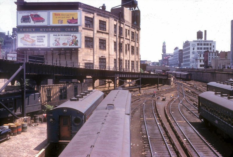
Bens photos show the small layup yard just east of the station. There were three storage tracks here and I would think they used these to hold rush hour equipment for over the bridge service only.


The second photo is on the Northwest side of the station. It is dated 1941 so Fulton and Fifth Ave service operates here. The tracks in the photo were from the original Myrtle Ave El which were used to access the upper level loops. There was a similar setup a block east of the location in the photo to bring the loops back to the Myrtle Ave el. Not sure how this was used at this time to 1944 .Perhaps some Lexington Ave and Myrtle Ave el trains turned around at Sands Street using these loops. When the Fulton Street El was closed to Rockaway Ave in 1940, The BMT continued to Operate a Rush Hour Fulton Street el service over the Brooklyn Bridge though Sand Street. These trains left Atlantic ave and joined the Broadway Line at Eastern Parkway, travelling west to Gates avenue onto the Lexington Ave Line , onto the Myrtle Ave Line at Navy Street and through Sands street to Manhattan. This service lasted to 1944 when the Brooklyn Bridge BMT lines were eliminated.  


The third photo shows the structure for the trolley wire for tracks used by BMT trolleys through the station.


The fourth photo shows us the connection on the right from the Myrtle venue El for service from these lines operating over the bridge. The other tracks were for the Fulton Street elevated trains and the Brighton Line through 1920.


So some additional Photos.


This one I believe was made when the sand street station was being built before 1900. It shows the area at the West end of the new station.


sands tr under construction


One the South Side, we can see the double loops on the upper level. There island platforms on two sides of the loop to expedite loading and unloading and maximize the number of trains using the upper loops. In the foreground we can see the stub terminal for the Fulton El at Sands Street as well as the spur that continued west to the Fulton Ferry.


img_132302


Here is a view of the Bridge line leaving the station. we see a BMT El Train and a trolley both on their way to Park Row. I am surmising that this photo was made in 1944 as both the train cars and the trolley appear to have notices about a service change in the windows. It looks like a white rectangular paper sign in the windows. This was a usual method of publicizing coming service changes in he day.


img_113235


On the East Side of the station. Not sure when this photo was made but it might be early. Could be a Fulton Train


Sands st Gate cars


 A Little further east and later in time, we see a Fulton El Train of C Type articulateds approaching Sands street from the Fulton Street El. Their was an S curve connector here at about Tillary Street. The C Types were the BMT's initial adventure into Articulated train sets . They were home made from el cars and Preceded the BMT articulated designs as the D Types, the Multis and the experimentals.


img_112757

Attachments

Images (5)
  • sands tr under construction
  • img_132302
  • img_113235
  • Sands st Gate cars
  • img_112757

EBT Jim, I do not remember thos NYC yards along the Hudson.  Note that the last picture shows the West Side elevated highway, which doesn't appear in the top picture or the sketch.


LIRR Steamer:  Thanks for the pix of the Tug.  Wanting to learn more, I googled its name and came up with a reail fans web site that had hundreds of picture of the Bush Terminal RR locos.

Similar, not the same.

Those are not former SIRT cars. The number details are different along with the blocked out first window. Also the first car has the round BMT logo. They are lacking headlamps as well.

Those cars in the previous photo and shown below never made it to or from S.I. Non FRA.


S.

Culver Line

Attachments

Images (1)
  • Culver Line
Last edited by SIRT

The city acquired 25 motors from the SIRT in the 1950s. Most were rebuilt for ise on the BMT division, primarily the Culver shuttle  and Franklin ave shuttles. Some were retained for use as work cars and yard offices. The cars that ran on the two shuttles had the center headlight removed as part of the rebuild and after the rebuild, they were repainted and had the new logo. Here are a few more photos. You can see where the center headlight was removed as there still are what look like the base of a bracket which held the light


You can see in the photo below the details to mount the center headlight


img_6766

img_113302


On the Franklin ave shuttle


img_87045


Here is a shot in the 36th st yard in 1954 before the BMT rebuild. Center headlight is there and the cars letterboard say Staten Island.


img_75771


Just out of the shop after rebuild and ready for Culver service


img_87190


On the CulverShuttle after rebuild


img_6755


The file attachment is a roster of BMT retired cars . the last line has cars nos. 2900 to 2924 and references them as SIRT motors.

Attachments

Last edited by LIRR Steamer

Add Reply

Post

OGR Publishing, Inc., 1310 Eastside Centre Ct, Suite 6, Mountain Home, AR 72653
800-980-OGRR (6477)
www.ogaugerr.com

×
×
×
×
Link copied to your clipboard.
×
×