The great pics continue!!!!
Peter


|
|
The great pics continue!!!!
Peter
Fort Lee and Edgewater were very much a part of the New York railroad scene A little further south of there was the New York Centrals Weehawken terminal. It was also serviced by NJ Public Service trolleys that had to climb a huge trestle. I worked in the buildings that were built in the location after the railroads were abandoned The Hudson Bergen Light rail services the area now over ex Erie trackage


Though, as only a casual visitor and mostly unfamiliar with the geography, this thread has become one of my favorites. The photographs and commentary have been outstanding and highly informative. Thanks much to all that have contributed.
Hi Bob The Binghamtom was a beautiful boat I ate there a number of times when it was open Here are some shots from your link of the interior
While in service


Here are the ones from restaurant days One thing I didn't know was that there was seating in the engine room


Hello,
I found these pictures in an issue of Traction Heritage (Vol 4 No 2, Selections from 1907 Electric Railway Journal)
I think I want one of these.


Regards,
Calvin
Thanks, Calvin.
That's the first time I've ever seen the interior of an S motor electric - my favorite loco. Lot's of empty space!
Jim
GREAT PHOTOS of happier times! ![]() Unfortunately also illustrating the capricious vagaries of fate!
Unfortunately also illustrating the capricious vagaries of fate! ![]()
Everything progresses towards a state of entropy and decay! ![]()
Jim,
Thanks for telling me what type of engine that is. ![]()
I was flipping through some Traction Model and Traction Heritage issues that my wife found at work. These pictures caught my attention.
Calvin,
The engines in the first photos are officially called the NYC S-1 electric. It still has the original single axle lead and trail trucks.
They found that it didn't track properly and soon substituted 4 wheel trucks on the front and rear. These are the engines that I used to watch in the south Bronx at the Mott Haven yards as a kid. ![]()
Lionel made models of two versions of this engine several years ago.


Jim
Would this pass for Sunnyside Yard? ![]()

Peter
GREAT PHOTOS of happier times! ![]() Unfortunately also illustrating the capricious vagaries of fate!
Unfortunately also illustrating the capricious vagaries of fate! ![]()
Everything progresses towards a state of entropy and decay! ![]()
Art:
I couldn't have said it better myself. Thank you.
Bob
This photo (circa about 1900) shows the view of Hunter’s Point in Long Island City from Sunnyside, Queens, which is just across from Greenpoint on the north side of the Newtown Creek.
Photo from the book, 300 Years of Long Island City; in memoriam of Vincent Seyfried, prolific historian and author.

Seeing that view of Hunters point from Sunnyside and the cow, recalls the early history of this land as dairy farms , What was not usable was marshland in the same area. At the turn of the century, these lands were largely undeveloped as shown in the photo . The PRR acquired these properties in preparation for the Sunnyside yard project which was a necessary adjunct to the Pennsylvania station project. In short, the land was too expensive in Manhattan for train storage and service and so Sunnyside came to be. The opening of the Quuensboro Bridge accelerated the urbanization of the area and it was just a few years later with the dual contracts that Flushing and Astoria Eles were constructed and placed into operation by the IRT and BMT . Thes companies operated the Elevated lines jointly until 1949.
We have a few views of the area to relate it to modern times.
The Track map presented in this image conveys the immenseness of the PRR and LIRR yard projects in Sunnyside and Hunters point as of 1956.

These railcars and trains at Sunnyside might be standing here where the cow was grazing in the 1900 photo.

LIRR S class Alco was working over near Yard A. The Snshine Biscuits sign and building was a landmark. The building us still there but the sign is not. The LIRR Alcos were originally ordered by the PRR for the LIRR before the PRR placed the LIRR in Bankruptcy in 1949. These locos were delivered in the Brunswick Green with Dulux lettering ala PRR . The LIRR painted the pilots white. They wore these colors for a decade or so before being repainted into Goodfellow colors.

here is an aerial view of the area . You can see the Flushing Line exiting the Hunters Point Ave station and curving to the top of the photo heading towards Queensboro Plaza. Just East of there, the Montauk LIRR branch curves onto the Main line leading to the Sunnyside yard and to the East on the LIRR

Ok Back on the Ground so to speak, we can see the yards looking east from the Flushing Line just as it turns north.

Still on the Flushing El, not quite one block north of the prior photo with a Nanhattan bound no.7 coming at us. The Tunnels under the east river were originally known as the Steinway tunnels. They were used by the Steinway trolleys before being bought for the IRT service. Low Vs once ran on these tracks into the late 1940s.

I think that cow would not recognize the place judging by these photos. Enjoy the visit.

Just came across this pic.....not sure it's been here before.....
I think I see:
The EL and ajacent yard by the Polo Grounds.
The New York Central Hudson Division ( and maybe the area of the Putnam Division yard)
The Jerome Ave EL/Subway #4
The New York Central Harlem Division with what looks like the car yard near Cardinal Hayes HS.
Peter

Here's another neat one.....taken in 1961.....look at the New York Titans logo!
Peter
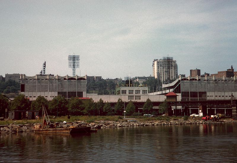
Hello Peter (Putnam)
Thats a nice photo taken from the Bronx shoreline to the Polo Grounds Stadium. Also note that it is also showing the ex-IRT 9th Avenue EL remnant "Polo Ground Shuttle" in the foreground....
However - PHOTO DATE OF 1961 IS WRONG -- the shuttle line closed in August 1958 and was removed by mid 1959 on the Manhattan Side. I would date that photo between late 1958 and earlier. I rode that shuttle many times and took photos of and on it about one month after it closed and abandoned- in August 1958.
Here are a few of the hundred or so photos I have in my Polo Ground Shuttle collection file.
And I am enjoying this long photos thread and the various commentaries !
Regards - Joe F


Looking at the arial shot of the area here are my comments.
The 9th ave el is up and running. You can see trains south of 155th St. Station. The Green lines yard North of the Macombs Dam Bridge viaduct and West of the el station is intact as the transfer table is visible. The area South of the Polo Grounds showing the diagonal area with no vegetation is the construction remains of the Ind Concourse line The Nassau houseboat that was present at the Bronx shoreline at Putnam bridge is not there yet. Sedgwick Ave. station is still intact with the NYC Putnam portion and the yard along Sedgwick Ave. Also visable. No Major Deegan highway yet. NYC. Highbridge yard has been reduced in size. (That area between the yard leads was where the Composites were stripped of their original trucks and had the Maximum traction tracks install for elevated operation. The Flivvers were also delivered there and had the Composite trucks installed. The yard remained like that for many years after the conversion was completed) The 3rd Ave. Railway yard North of the Bronx side of the Macombs bridge viaduct and West of Ogden Ave. has been removed. The Yankee Stadium is up and so is the Bronx County Courthouse. There are little To no automobiles in the photo. My best guess is the photo was taken in the early Thirties.
Nate
Hello all
As long as we are on the ex-9th Ave EL POLO Grounds Shuttle line and area - here is what I have to offer - in a few sets of Before and After scenes -- including an architect's proposed new development planned to re-claim to entire Shuttle Line R-o-W and real estate Between Anderson Avenue and Jerome Avenue - of which I have photos of. I will later post photos of the Anderson Avenue side of this proposed complex.
I have provided LOCATION Captions under each photo.
For those interested in this long abandoned EL line, and who may be personally family-connected to it and the neighborhood as I was in the 1950's thru late 1960's, Enjoy !
Regards - Joe F

ABOVE - 01a-N on Jerome Av to Anderson STA-9AV EL-1920's-
")
ABOVE - 01b-N on Jerome Ave to ex-9AVE EL Anderson STA crossing-2011

ABOVE - 01c-N on Jerome Ave at Ex-IRT Anderson Ave EL STA-2013

ABOVE - 02a-N. on Jerome Ave to Anderson AV STA-9AV EL-1920's

ABOVE - 02b-N. at Jerome Ave to site of ex-IRT Anderson STA-2013

ABOVE - 03a-W on NB Track to Anderson STA-9AV EL-1939

ABOVE - 03b-Proposed redevelopment-West to Ex-IRT Anderson Av abandoned Station
property and location

ABOVE - 04a-SW to Wall-end remains-Anderson STA-9AV EL-2004

ABOVE - 04b-S on Jerome Ave At ex-Anderson Ave IRT EL STA-2013

ABOVE - 04c-Proposed Redevelopment-SW on Jerome Ave to former location Anderson AV STATION

ABOVE - 05a-Old ex-9AV EL-Polo Grounds Shuttle W.162 St route

ABOVE - 05b-New Yankee Stadium now sits on Polo 9AV EL R-o-W-2012

ABOVE - 05c-Proposed Redevelopment-aerial showing new one block constr. on ex-IRT Anderson Av Station

ABOVE - 06a-N.E. on Jerome AV to Anderson AV STA-IRT Polo Shuttle-1955

ABOVE - 06b-N.E. on Jerome AV to where IRT Anderson AV STA crossed-2013

")


Nate & Joe......thank you so much...great information...in 2009, my son and I had our 1st trip to the new stadium.....I will did up my pics of the remains of the shuttle take off from the #4 and post them.
Peter
The remnants of the el at Yankee stadium makes it looks like the tracks were part of the stadium. As joes map shows the route goes right through what is now the stadium This is River ave where the 9th ave el tracks would be on the lower level and curving toward the river. This pic was taken before the new stadium was built Have to get an updated one

Just came across this pic.....not sure it's been here before.....
I think I see:
The EL and ajacent yard by the Polo Grounds.
The New York Central Hudson Division ( and maybe the area of the Putnam Division yard)
The Jerome Ave EL/Subway #4
The New York Central Harlem Division with what looks like the car yard near Cardinal Hayes HS.
Peter
This picture shows how deep center field was at the polo grounds Imagine todays primadonna hitters dealing with 455 foot center field wall It was short down the lines though. Also the coach yard just to the north of the Polo grounds was huge The yard was elevated and there was a ramp down to a few tracks beneath it that was used for MOW. These two pics were borrowed from the ERA book entitled The Elevated Railways of Manhattan


Here are my pics from the spur next to the new Stadium:


Peter
Peter,
Great picture! Across the river, there is some sort of housing project that has around 10 or 11 or so towers as part of the structure. Just west of that there is a lower, long building. Could that be The Put's engine house, with the north side showing evidence of sand along the ground where the steam engine's were serviced?
Tom
Could be, Tom.......maybe Skip will weigh in.
Peter
Pretty sure that is it. To the west of the engine shed would be the tower. If you have Joe Schiavone's The Last of "The Old Put," on page 6 it shows the track diagram (I think that I gave or sold that to him!) and the picture on page 7 shows the tower and the engine shed. The picture on page 7 also shows a much smaller shed-type of structure just north of the tower and still alongside the shed, which seems to match the aerial photo.
Tom
Tom,
As I recall the tower was located on the curve from the structure East of Putnam bridge on the curve into the Putnam right of Way on the North West side of Sedgwick ave station. The steel work remained there until the end of IRT shuttle service. The tower was a brick structure. The engine house was on the West side of the Put's tracks parallel with Sedgwick Ave. It was removed during the construction of the Magor Deegan Highway and the reconfiguration of the Station. I remember riding my bike on the Deegan before it opened. Then riding across Depot Place.(Highbridge Station) , then down the ramp into the vacant lot that was once Highbridge yard. We went South along the shore until we came to the tower which was behind the Nassau house boat. There were pilings that were remains of piers all along the shore and south of Macombs Bridge. At one time that area was a resort area with hotels, boating and fishing as well. Kids would go swimming and dive off the absolute sidof Putnam bridge. Some would get fatally injured by hitting their heads on the underwater remains. My mother told me never but never go swimming in the Harlem River. When I saw the sewer pipes spewing out the waste into the water I would not even go near the water for the smell alone. Talk about pollution!
Nate
Good evening Nate,
The Schiavone book shows a wooden tower identified as the "High Bridge signal tower B" directly next to the engine shed.
Tom
PS- Probably good to still follow your mom's advise to not swim in the Harlem River nowadays either!
Tom
Tom, Which book of the 3 volumes is related to the Bronx portion of the Put? My interest is in the Manhattan Railway 9th Ave El and the Polo Grounds Shuttle. If you would be so kind to email me the info I can look for the book or books. I will take your advice and stay out of the Harlem River.
Thank You,
Nate
Hi Nate,
Nate,
I don't see your email showing. The book that had the engine shed picture and the adjacent wooden tower was the one I mentioned, from Joe Schiavone's The Last of "The Old Put," , which I think was his third book. I probably have his phone number at home if you need it. My email address should show, so feel free to email me.
Tom
I am very intrigued......I will certainly be pulling out my Schiavone books this weekend!
Peter
Fantastic stuff. Many are of items I've never seen before. You definitely get a feel for days gone by.
--Greg
Back on the Polo Grounds Shuttle:
I stumbled onto these three photos on the internet captioned as showing construction on the shuttle route. The first two are on the Sedgwick Ave end of the tunnel and the third is near Anderson Ave. You can see a steam loco on the Putnam line in the background in the second photo
Steam was banned in Manhattan, but was still allowed in the Bronx. It was rare by the time I was old enough to appreciate such things in the early 50s, but I did catch a few glimpses of a passing steam engine.


Jim
Hello Jim P --
The, your, 3rd last photo is actually LOOKING NORTH on the west sidewalk side of ANDERSON Avenue just below where 162nd Street (over the shuttle tunnel) crosses and dead ends in to. To the right - where 162nd St ends - see the 2 story building under construction - as it is to be the NEW headhouse for the Anderson Avenue end of the Anderson - Jerome Avenue joint station.
The head house included offices above and stores and shops on the sides of the dorward for the station entrance. I know this area and the shuttle very well as my father lived in the block and I rode the shuttle many times. Here are three images looking EAST on 162nd Street towards the former headhouse of the station and Anderson Avenue crossing left to right. Also note the 4th image;


The ABOVE image is looking NORTH up the hill on Anderson Avenue to the facade of the former station headhouse of the Anderson-Jerome Avenue Station . !62nd St dead ends at the left sid of photo -- and indicated in top 3 photos
Regards - Joe F


Access to this requires an OGR Forum Supporting Membership


